• MY BOOKS ON WILDLIFE, GARDENING AND MORE

  • The Wild Excellence

  • True stories of wildlife encounters around the Greater Yellowstone
  • Award winning eBook on Decomposed Granite, tips, how to's, what to watch for
  • Children's book. True stories of a dog and wolves. In a dog's voice
  • Written for dry Mediterranean climates in California, north and south

Ways Not to Treat Our Lands

Living next to our first National Forest, one can’t help feel like a caretaker.  So when I see abuses, I  shake my head and wonder “who would do this?”  “How can they come out here to enjoy this vast awesome wilderness and throw their beer cans as they walk around?”  It makes no sense to me.

Hunters left this trashy campsite which I found today. Along with their empty shells there were plastic water bottles all around the site. I packed it out for them.

People use our public lands everyday.  They enjoy the great outdoors in a myriad of ways, from hunting and fishing to just lazing around in the camper next to an open fire.

There’s a movement in Congress that all of us–the public who cherish the outdoors–need to be aware of.  Many politicians are actively trying to privatize these lands.  What does that mean?  It means that there would be a wholesale sell-off of lands that belong to all of us.  And who could afford these lands?  Only the very wealthy.  Once those lands are private, they are gone forever.  No longer will we be able to hike, hunt, fish, bike, or walk over them.

Public lands are accessible to people of all income and walks of life.  Even now, in the great state of Wyoming where I live, things have changed over the last 20 years.  Where it was understood people could cross private lands to fish, and large ranches were owned by your local neighbors, now the only people who can afford these large tracts of land are the extreme wealthy.  They are the Bill Gates, the hedge fund owners, the Texas oil men.  My neighbor who owns all the bottom lands here doesn’t live here (I’ve never met them), rarely visits, runs cattle for a tax write off, and is among the 50th wealthiest individuals in the world.  If the Ryan budget has its way, much of the lands that are now open will be closed to everyone but the wealthy and their friends.

And that brings me back to what we all cherish.  These public lands are our generation’s bank account for our children.  We are only its’ stewards.   When people leave trash around, or tear up areas with ATV’s, or poach wildlife, or a myriad of other abuses, they are forgetting that these lands belong to you, me and everybody, and future generations.

Five ATVer's tore up this meadow on National Forest lands in Idaho

So, thanks for being a great steward. Enjoy OUR lands.


Frank revisited

I’m going to revisit an old post about Frank Hammitt.  In my previous post I told the story of how old Frank really died.  Frank Hammitt worked for the Forest Service even before there were rangers around here.  There’s a nice stone memorial with a plaque by Antelope butte.  Stories abound.  He was in a snowstorm with his horse and couldn’t see.  They fell over the side.  He committed suicide.  On and on.  It’s great, classic folklore around here.

But the real story is that they found old Frank’s body not over Antelope butte, but much further down, on the side of the Clark’s Fork.  “He was pretty ripe” my neighbor said.  No one really knows how it happened.  They just found his horse wandering around and went looking for Frank.

Is this where he fell from? Ledge near the burial site

Well my old neighbor who grew up in the valley told me there was a box, Frank’s coffin, near the cliff.  The box was an old wagon box and they brought Frank up and buried him near the top of the cliff where they found him.  Some years later, some of his friends thought that wasn’t a proper burial so they brought a wagon down to the coffin, collected his bones, and brought him up to where the present memorial is.  The CCC then built the plaque.

Last fall I heard this story and guess what?  A few days ago I found that box, just as my friend Jack said.  I was lucky to run into it.  Although its not hidden, its obscure and I just happened to wander over to a nearby elk skull to inspect when I noticed the box.  The box is about 6’6″.  I thought it was an awfully nice place to be laid to rest; actually much nicer than right by the highway, even though you get signage, a special turnaround, and a plaque of your own.  Frankly, I’d prefer the rock and the ephemeral pond.

Hammitt's coffin next to the boulder

Another view of the wagon box coffin

View of the area. Ephemeral pond in this meadow

Plus, as a bonus, the mountain goats hang around you.  Up by the highway, its too exposed for the wildlife to browse near your gravesite.

Goats near coffin

Goat track

Yes, I’ll take that rock any day.

Frank Hammitt Memorial 1869-1903

I’m here to set the record straight.  And although a page on the Shoshone Forest Service website has it correct, I’ve heard a lot of tall tales since I’ve been here about what exactly happened to Frank Hammitt, one of the first forest rangers in Sunlight. If you see Antelope butte from Dead Indian pass, its an amazing formation.  Perfectly flat, its accessible only from its north side, which is now on private land.  I understand that buffalo were run off its edge by Indians. A friend of mine found a very old skull once in the woods below.

Antelope Butte

The ‘stories’ I heard when I first moved here about Frank were that he 1. committed suicide by jumping off the side of the butte or 2. it was a very foggy night.  Frank was riding his horse on the top of the butte, didn’t see the edge, and fell to his death, horse and all or 3.  he was drunk and fell of Antelope Butte on a foggy wintery night.

another view

My neighbor who was born in 1923 and grew up in the valley told me this story:

“My grandpa and dad knew Frank.  They found his horse wandering around.  Whenever you see someone’s horse, you know you better start looking for them.  They found Frank on a ledge over the cliff on the Russell Creek side near the canyons’ edge.  There was a pile of smoked cigarettes on a rock nearby.  Hard to say what happened.  No one knows.  He was pretty ripe.  Been there a while.  Pretty ripe.”

J___ shows me a photo.  There’s a large box, coffin like, without a lid.  The box is butted up against the side of a large boulder,  wedged between several other large rocks.  A pile of smaller rocks sits to the side. There’s no bottom to the box and some old bones sat inside that looked like an elk pelvis.

“That’s where Frank’s body was.  Its really a wagon box. They covered it and put rocks over the top.  Down by the cliffs on the Russell creek side.  You can still see the wood down there if you can find it.  I was young then and my dad used to say to us ‘You boys just stay away from that box.  Don’t git near there’. After some time, a fellow living on the other side of the road where the highway department is now, well, he decided that Frank needed a more proper burial.  So he took his wagon down there, collected Franks’ bones.  And you know, he didn’t get them all.  There’s still some bones in there.  But he collected them and brought them up in the wagon to the place where the memorial is now.  He buried the bones there, stuck two posts in the ground.”

“That was around 1938, and so the CCC (Civilian Conservation Corps) was around and they built that memorial that’s there now.  Folks will tell all sorts of stories, they like to talk about Frank dying by falling off the butte.  But that just not what really happened, and here’s the picture to prove it.”

See the flat butte in the middle. From Dead Indian pass

I suppose next summer, or maybe this winter, I’ll just have to go looking around for that old box. The lumber is still around to prove it.  And when I find it, I’ll post the photo for you to see.

I Love the Winds!

Here are some photos from my 8 day backpack this summer to the Wind Rivers, my most favorite place in the world.  I’ve been there at least ten times or maybe more.  This time I went back to a place I was 10 years ago because I wanted my friend to see it–Island lake near Titcomb Basin, one of the premier places in the Winds.  The weather was fantastic, even somewhat balmy.  Our packs were each about 25 pounds. Koda carried his own freeze-dried food and some of ours.  I call him my Sheepeater dog.  That’s because the original peoples in these mountains, the Shoshone Sheepeaters, never had horses, but packed up their dogs with saddle packs, just like the one Koda carried, with all their supplies.  Here he is below after a dip in a lake by the trail, getting a brief break from his load (me too).

Photography Point on the trail to Island Lake. Continental Divide in the background

One of the hundreds of unnamed lakes. This one beautiful and inaccessible

Island Lake sits at 10,300′ with the rugged peaks of the Continental Divide as the backdrop curtain.  The full moon rose over the lake as the sun set to the west.  The moonlight, reflecting off the granite faces, basked the mountains in an eerie and beautiful light.  It was so bright you could easily hike without any additional artificial light. It’s impossible to describe the strange beauty of that night landscape.  That was the night I understood the craving mountaineers get for high places.

The wonder of the place is that it is as it was 10 years before and only because no human can live so high all year long, so it is preserved as part of the Bridger-Teton wilderness.  The next day we hiked into Titcomb Basin, a gorgeous aquamarine-blue lake at the base of the access to the highest peak in Wyoming–Gannett Peak.  We had passed many people on the trail that attempted the ascent, but few had made it.

Island lake

We rested at Upper Titcomb Lake.  A weasel came out from the rocks a few yards away and gave us a good show.

Interestingly enough, at both Island and Cook Lakes we were visited every night by Calliope Hummingbirds.  Each night she’d fly close and inspect us and every bit of our camp.

Hike into Titcomb Basin

Usually by the first or second week in August the mosquitos have abated.  But this year we were three weeks behind and the bugs were bad.  We’ve had almost 600% of normal snowfall this winter with a slow melt.  The campsite we chose below was on a knoll with an open area that caught the breeze. If you were in the trees, watch out–the bugs were prolific.  But a smokey fire, good 100% deet and a mosquito net got rid of the worst of them.

Campsite

The next day we hiked up to Indian Basin. Although I’d been to Titcomb before, I’d never been to the Indian basin and the pass.  Actually, its no longer an easy route to find.  At first we followed some cairns that led us up the wrong route, coming to an impassable area of the river.  We backtracked and realized we needed to cross down below, where huge boulders made for a treacherous cross.  We probably lost a few hours there.  But it was worth the effort.  Indian Basin is the starting point for those who want to climb Fremont Peak, a non-technical climb up a lot of talus.  The Basin is pure granite, the top of the world at the Continental Divide.

Indian Basin

Wow, breathtaking Indian Basin

We had inquired at the ranger station about Lester Pass.  Since the snow melt was so late, I wondered what the highest pass in the Winds might be like.  The pass was clear but on the downslope–boy what a snowfield we had to cross and it was steep.  I took my pack off, held onto it and my breath, and slide down on my butt.  What a ride!

Our destination for the second half of the trip and the loop was Cook Lakes.  I’d never been to this part of the Highline trail.  Cook Lakes are a beautiful set of lakes set in a cirque of above timberline peaks.

Lower Cook Lake

Upper Cook Lake

A pika entertained us while we hiked into the Lake area.  Fishing was excellent and helped supplement our bland backpack food.

The sad part of our journey was the proliferation of dying Whitebarks.  At the uppermost elevations of timber, the White Bark Pines were in better shape, with maybe only 20% dying or dead.  But as you got lower in elevation, even around 10,000′, over half of the trees were dead, most of these being the large, multi-trunked ones, probably hundreds of years old.  These trees are dying not just from blister rust, but the double whammy of rust, beetles and climate change.  White Bark Pines are considered a keystone species.  They will be extinct in just a matter of a few years in the Greater Yellowstone Ecosystem and are now already considered functionally extinct.  These are trees that can live 1000 years and humans have been able to alter their environment to such a degree that this has happened very suddenly in only the last 20 years.

The forest service office let us know that we must secure our food because grizzly and black bears are frequent visitors to the Winds now.  One outfitter told us that a Grizzly sow and her cubs had holed up all summer in the New Forks drainage.  Not a surprise since there was a fire there several years ago.  Grizzlies like burned areas.  But on the entire trip I didn’t see any bear sign except about 5 miles from the trailhead I spotted off trail an old bear scat from the spring.  Much ado about  nothing still. Yes, there are a few bears that are reaching the Winds, mostly in the Green Rivers area.  Bears that get into the southern areas come into conflict with sheep and are quickly moved.

Even though much of Bridger-Teton is Wilderness, sheep grazing allotments were grandfathered in on the southern half of the range.  Where we were this year there are no sheep, but last year I was north of Big Sandy where hundreds of sheep had just gone down to the lower country.  I had a bum water purifier and got giardia from those sheep.  To me, wilderness and sheep no longer are compatible.  There just have to be some areas we leave to wildlife.  Transporting bears out of wilderness in the few areas where they can make a living, for the sake of protecting sheep makes no sense in this age of diminishing land.  The sheep have private lands they can graze on, grizzlies don’t.

The hike from Cook Lakes back to Elkhart Park is a maze of creeks through the Pole Creek marsh.  The Fremont Trail hooks into this area and I never saw the connection.  We ran into scores of hikers, including one boy scout troupe, that were simply lost and disoriented.

Crossing Pole Creek

Lake on the Pole Creek trail. Hate carrying that backpack. See Koda's pack...

One of the jewels of the Winds that we discovered on our hike out was Mary’s Lake. We loved that little lake surrounded by a rocky shore.

Campsite at Marys lake

Mary's Lake


My friend above Elkhart Lake

All fun things must come to an end.  Here we are on the trail home.

Hike into the bowels of the Clark’s Fork Canyon

We are going to hike into that canyon in the photo below.  From this photo you can see the mighty Clark’s Fork of the Yellowstone, the only wild and scenic river in Wyoming, un-runnable.

To the left you can make out Sunlight falls, where Sunlight creek meets the great river.  What you can’t see is that just in front of the falls is Dead Indian creek running into the river as well, almost at the same spot but not as a falls.

Some day I’m going to take a raft down to the river and paddle upstream to that meeting place, but the Clark’s Fork needs to be slow and low.

There are a few trails down there from above, most fairly treacherous or extremely steep.  The best runs near Dead Indian Creek from the road.  There used to be signage with the mileage but someone took that down.  Its four miles to the river, but its the last 3/4 mile that’s straight down.

ANother shot of the canyon.  See the little person to the middle right

Its an all day slog, and take water because there is none until you reach the canyon.  Even though it wasn’t incredibly hot, the dog was panting heavily and needed the extra water I took for him.

That’s because its a fairly exposed hike.  And plan to go in mid-August when the river is slower, take a lunch and chill…

Looking downriver

Looking upriver

Chillin’

The hike out is not welcome after the great rest at the river.  Another alternative is to shuttle, leave a car at the mouth near Clark and hike down from the Sunlight Road.  Someday I plan to hike an inflatable raft down there and spend a few days exploring upriver.

Windy Mountain

The hike to Windy is not long, but an uphill climb.  You can drive the 4 wheel dirt road to a parking area, which cuts out a few miles.  But for some reason I hadn’t yet hiked to the top…either there was still snow, or it was too hot, or the bears were using it in the fall.  There’s still White Bark Pines that are living up there and its bear area when the nuts are ripe.

But finally after 5 years I made the trek.  The view is a great 360 and that’s why there used to be a fire lookout there.

Foundations of old lookout tower

The Beartooths still had snow on them.

Beartooths

The most wonderful highlight of this hike, aside from the views, is the old outhouse.  Try imagining going to the bathroom here!  I wouldn’t even get close, though for the ranger there was no clean-up!

Outhouse on cliff edge!


Another view

An old crude telephone line still had the poles standing.  Its really quite a ‘hump’ to the top so I can imagine the pack horses carrying all this stuff up there, including the concrete.  Probably built by the CCC I would guess (when just about all the country infrastructure was built).  A surveyor’s marker from the 30’s said ‘Do not remove or there’s a $500 fine’.  That’s a lot of money then.

Old telephone line poles

Telephone line into the distance


Although the map shows a clear trail leading north into another drainage called Reef Creek,  the trail was not visible on the way up.  I’ve been trying to find that route from the Reef Creek side so I kept my eyes open.  There was no clear trail, but by bushwhacking a bit, we found the link and several hundred feet away a trail opened up.  I’ll be hiking that this fall!

Yellowstone adventures and a close call

I came back a few weeks ago from an advanced tracking class with Jim Halfpenny in Gardiner.  But before the class, I spent a day and an evening hiking around the Park.

Tuesday late afternoon called for a trek up Mt. Washburn, which I’d never done.  They say if you only have time for one hike, Mt. Washburn is your ticket.  Its a great view for sure of the Yellowstone volcano, but what’s more impressive is that during the ice age only 30,000 years ago, Mt. Washburn was the only land not covered with glaciers from there to the Tetons.  The hike is not far but a good uphill and the alpine wildflowers were impressive.  A group descending came bye and told me to watch for a grizzly they’d seen near the summit.

View from Mt. Washburn of the Yellowstone caldera

Polemonium

Pedicularis

Gentian close-up

At the top, a ranger is stationed and there’s a free telescope for viewing (Wow, something actually free!).

Wednesday morning after camping at Mammoth, I headed up past the Golden Gate looking for a nice dayhike.  I thought I’d do Solfatara Creek.  I parked at the isolated trailhead.  Not my favorite kind of trail presented itself.  An ’88 burn area, the trail was thick on both sides with young lodgepoles so tight you can’t move nor see ahead.  Essentially, these kinds of trails are like tunnels and I don’t like them because if you come upon a bear there’s no where to go.

I decided to try the trail and see if it opened up.  If it didn’t, I’d find another to hike.  Sure enough, after about 700 yards, the trail opened to meadow and an unburned forest.  As I approached the hot springs of Solfatara Creek, the trail showed lots of fresh bear sign.  The creek was a beautiful and unusual greenish-blue, warm, slow water, but the mosquitos were thick.  Between the bugs and the bear scat, which was thickening in tune with the mosquitos, I decided that since I was hiking alone I’d prefer to find another trail, one more open and less buggy.

I retraced my steps and when I got to the meadows, I noticed a troop of rangers off trail looking like they were doing some kind of vegetation studies.  I figured they must have come through the ‘tunnel’ that was approaching, so maybe they’d scared off any bears.  But just in case, as I always do when I can’t see well in front of me, I took my bear spray out of its holster, uncapped it, and held it in my right hand as I came through the trees.

About halfway through the forest, I came around a corner almost directly into a lone bison bull rubbing its horns on a sapling.  I watched for a moment while debating where to go to get out of its way.  He was coming my direction and I was headed towards him.  If I went backwards from whence I came, I’d be stuck in the narrow thicket of trees on the trail in his way.  I couldn’t slip pass him. Beside me was a teeny, tiny clearing of about 5′ square.  I moved as far as I could into the clearing.  He began to trot on the trail past me, but just at the last second he changed his mind and decided to charge me.  At only about 6′ away, he lowered his head; his horns now directly facing my chest.  Instinctively, I sprayed him with the bear spray I’d luckily been carrying unhinged and uncapped.

Immediately he made a right turn and trotted off down the trail, swinging his head side to side since his eyes were stinging.  I left the trail, totally beefed up on adrenaline and thanking my lucky stars that it wasn’t my day to die.  Bison scar me way more than bears as I feel they are much more unpredictable, way more dangerous, and definitely not as smart.  This guy didn’t seem threatened by me.  For him, it was more like I was challenging him, offering him a chance to have a sparing match. An old lone bull like him is a cranky old man.

Lone bison but not my bison

Grizzly lake, my destination after Solfaterre

On the way back to Mammoth, I got stuck in a bear jam.  Two black bears were feeding on one side of the road and decided to cross over.  What amazed me wasn’t the bears, but that people got out of their cars and ran as fast as they could towards the bears, getting as close as they dared to take photos.  Luckily these bears were used to people, but not all bears in the park are that amenable.

Guy in the white T shirt on left is almost right on the bear

In this one you can see the bear and the lady in front not even paying attention!

Halfpenny always leads a fabulous class, highly recommended.  The mornings were spent in the classroom and the tracking museum.  He has a fantastic collection of plaster casts and other assorted items to help you to learn to track.  The afternoons were spent in the field.  Here is a track of a badger of which I made a cast.  The upper left hand corner contains a coyote track as a bonus.

Badger track (coyote track upper left). Notice long claws

Young bull moose

More BLM thoughts and Jack Turner’s new book

I just love Jack Turner’s writing.  He hasn’t written much, but the stuff he does write is great.  His easy style of writing weaves a lot of good facts, ecological outrage, and story detail.  I’ve just finished his new book “Travels in the Greater Yellowstone”.  Each chapter explores a different area of the ecosystem, either with his wife Dana, or sometimes hiking with a friend.

Turner spurred some additional thoughts on my last entry regarding the Big Horn Basin BLM plans.  The commissioners in the surrounding counties got together and hired, with our tax dollars, a company to do an analysis of oil and gas in the basin; really paying them to turn out a document that would support what the commissioners want.  From the presentation the company gave at the commissioners meeting, they did a good job distorting facts to support massive development as a sound idea.  For instance, they had slides of pronghorn and deer around gas wells.

Now for a pertinent comment by Turner in his chapter on the Green River Lakes, where the Jonah and Pinedale gas fields have taken over the Pinedale area:

“What is the status of sage-grouse populations here?  As usual, none of the interested parties agree about the numbers–counting is political–but no one denies that this basin is one of the species’ remaining strongholds and that it is suffering plenty.  One study suggests that the 1,200 or so sage grouse that live around the Jonah and Pinedale Anticline gas fields will be gone in twenty years.  The government, worried sick that Endangered Species listing will radically curtail energy development, has called for a Sagebrush Grouse Summit.  Nor is it just the grouse that are a problem.  The mule deer population has already declined 46 percent in the area around the Pinedale Anticline field.  They are supposed to be protected in the winter by limits on drillings, but the limits are a farce.  The energy companies can request exemptions and the BLM grants damn near every one of their requests.”

Turner is my kind of guy.  He is no-nonsense blunt when it comes to the environment.  For those who are thinking in support of Plan C, the commissioners drilling dream, here’s another wonderful quote:

So…Wyoming has another energy boom–there have been many.  And when the boom collapses–all booms throughout history eventually go bust–the resources and traditions that could have sustained the state for centuries will be gone.  Who will want to vacation in a Superfund site?”

That is my bold and for good reason, because our commissioners have forgotten what we love about the Cody area and why people come to visit here. They also seem to have forgotten the amount of revenue that comes from tourists.

Big Horn Mountains looking from the Big Horn Basin

At one time, I was going to buy land in the Pinedale area.  This was before the boom.  I’d been coming there every summer since 1996.  I’d stay at the wonderful Wagon Wheel motel, a tiny place that’s been there forever.  The town was just one street with no good restaurants, but a great outdoor equipment store.  It was nice and sleepy and I loved it.  Jackson was an hour and a half away, through the Hoback Canyon, “a canyon that in any other part of the country would be a national park“.  Pinedale reminded me just a little of Jackson in 1972 when I first came to these parts.  I could live here, I said to myself.

But then things changed, almost overnight.  The next summer I arrived and there was an Americinn, charging $265/night vs. my little motel at $50/night, and all the hotels were booked.

“What is happening here?”  I asked.  The Jonah field, they said.  It was the beginning.  From what the townspeople told me, Bush/Cheney more than tripled the amount of lease permits allowed to be issued for drilling per year, pushing them through with little regulations, and nixed the required townhall meetings.  That was over seven years ago and back then the townspeople were complaining about the lights to me…”You can see those lights in the oil fields from up in the Wind Rivers”.  There’s been a lot of growth since then, so much so that ozone alerts occur regularly in the winter.  They have worse smog/ozone in that area than the whole of  Los Angeles.  Needless to say, I was no longer going to buy property there.  I began looking around Cody and the first thing I asked my realtor was about oil/gas development here.

“The oil fields are all old and pretty much maxed out”, he said.  What he nor I didn’t consider was new technology and the nation’s thirst for energy.

Last summer I drove, quickly, through Pinedale up from the south on my way back from a trip through Big Sandy in the Winds.  Miles of tacky housing fills the once open spaces, probably houses for the workers.  The growth in just the last seven years, or degradation of the environment depending upon how you look at it, is amazing.

“Seventy percent of the Wind River lakes that are more than 9,000 feet have low alkalinity levels, hence they are particularly vulnerable to the consequences of oil, gas, and coal-bed methane development upwind in the Green River Basin and Wyoming Range, which will disgorge a cocktail of toxic fumes into the air twenty-four hours a day for the next fifty to hundred years.  The Wind River Range and its three crown jewels of America’s wilderness system have the misfortune to be immediately downwind.  Air standards already are being violated with only 600 wells in operation–and with 10,000 more planned, pollution can only get worse.”

Our last wild places in the lower 48, where grizzlies can still roam, and pronghorn can still migrate, are being chopped up and compromised.  If this is not an outrage, then we are not awake.

Hear ye, Hear ye, Commissioners:

“When people ask what Wyoming should do with those billions of dollars in mineral royalties left over in the budget, I say: Invest them.  Future generations in this state are going to need more than billions to clean up their wasteland.”–Jack Turner

An Open Letter to the BLM

I decided to publish my letter to the Bureau of Land Management regarding its draft resource management plan.  This is the plan that will determine use for the next 20 YEARS!  Twenty years these days is a very long time, and so many changes will happen that are unforseeable.

The Basin is huge, extending from the Shoshone Forest of the Absarokas on the west side to the base of the Big Horn Mountains on the eastern edge, north to the Montana border and south to Thermopolis.  Predictably, the commissioners of the surrounding counties of the basin are only interested in $$, what they can put in their coffers right now to grow and develop and that means oil and gas leases. They envision Wyoming as the Saudi Arabia of coal, gas, and oil, with cowboy sheiks.  But as Jack Turner so eloquently puts it in ‘Travels in the Greater Yellowstone’:  

Well, I reply, go to Saudi Arabia and take a good look.  Saudi Arabia is butt-ugly from energy development.  Do you want the Yellowstone country to look that way?  I don’t.  And I’m not so sure about those cowboy sheiks, either. The energy companies stand accused of bilking the U.S. Treasury out of billions of dollars–that’s our money for developing our resources on our land, and many of those companies are subsidiaries of foreign corporations whose headquarters are in places like Canada and the Barbados.” 

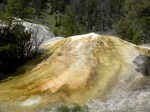
Weatherman's draw is a beautiful place. Shall we drill here?

The Bighorn Basin, as part of the Greater Yellowstone, belongs to all of us and our voices need to be heard.  We need to preserve the few places left for solitude and natural enjoyments.

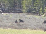
Pronghorn migrate and live in the basin. Should we disturb more of their habitat?

 I urge everyone, everywhere in the U.S. to give your comments on this plan at this website.  Your few minutes could make a difference for the next 20 years.

Tipi rings, as well as other Indian signs, are all over the basin from 10,000 years of habitation

Below is my letter to the BLM:

Bighorn Basin RMP and EIS

Bureau of Land Management

Worland Field Office

P.O. Box 119

Worland, WY 82401

Dear Mr. Hiner,

The Big Horn Basin is one of the most unique and special areas in the lower 48.  A traveler can walk the landscape and observe ancient seabed fossils or fossilized bones from extinct animals.  A few steps away are arrowheads or petroglyphs from the earliest Americans 10,000 years ago.  And within view are herds of pronghorn, elk, and maybe a coyote or wolf or a golden eagle.

The Basin is essential to the Greater Yellowstone Ecosystem.  It provides migration routes, calving grounds, and a necesssary corridor for resident species to maintain contact with their own kind, ensuring genetic diversity.  The Absaroka-Beartooth Front in particular is a critical component of the GYE.  This portion of the Ecosystem is predicted to be among the most resilient to climate change given the intact nature of the landscape and its topographic variability.

The future of these lands is at risk in so many ways.  Between habitat fragmentation and climate change, real estate development on adjacent lands and overpopulation, we need to ensure that our public lands serve the preservation of the limited amounts of wildlife that are left, most of which are squeezed into the GYE and its corridors.

I have been lucky enough to live in this area and view its abundance, even though, as we all know, so much has been lost over these last 200 years.  And that is really the point: What will we do, as a generation, to ensure that no more is lost?   What we will do so that our children’s children do not say “You once could see sage grouse mating here, but they are now extinct”?

The Big Horn Basin and the Greater Yellowstone Ecosystem face great challenges ahead, Climate change is a large Unknown and an unpredictable monkey wrench.  Add to that the known factors of endangered or threatened species, plants and animals.  With this in mind, Alternative C is a very dangerous and short-sighted plan.   Alternative C is all about money.  Alternative C values only profit, and what can line someone’s pocket.  One cannot put in the bank the emotional and spiritual value of Land, the sense of awe and wonder, and how much it feeds the soul.  Oil and gas development over the entire basin will compromise not only our water and air, but fragment habitat through roads and intensive use.   We will lose, even if so incrementally that people just forget as a new generation grows up, what we have today.  Memory is short, and what scientists call a shifting baseline has already happened in the Basin.  We need to return our lands to a previous, more healthy baseline, not degrade it further with an open hand to oil/gas development.

In light of these concerns it seems obvious that Alternative B would provide the best safety factor for the future of the Big Horn Basin.  We really do not know what our earth, or this area, will look like in twenty years’ time.  We cannot take into account all the rapid changes we’ll encounter.  We are losing species at an alarming rate that nobody could have predicted thirty years ago.

In terms of specifics of what is most important to me in the Basin:  I spend a lot of time in the winter hiking in the basin, particularly around Oregon Basin and the Badlands of Polecat Bench.  In the spring when the area opens up, I love to hike the Absaroka-Beartooth Front, Chapman Bench and the Clark’s Fork.  I relish observing the fossils and finding tipi rings.  In my day hikes, its now easy to avoid oil/gas development areas.  The Absaroka-Beartooth Front MUST be protected as a Management Area (AFMA).  Its abundance of wildlife, habitat quality, and scenery are unrivaled.  The oil and gas leasing restrictions for this area laid out in Alternative D appear to be impossible to manage given their checker boarded nature.  I feel that the best way the BLM can protect the world-class biological and scenic values of the Absaroka-Beartooth Front is by designating the area as unavailable for oil and gas leasing (Record #4080 alternative B).  I support the creation of the Clarks Fork Canyon ACEC, as well as the creation of the Chapman Bench ACEC (Record #s 7105-113 and #’s 7084-83 alternative B).  These areas are special to me.  Alternative B also provides the most protection for sage grouse leks, something the BLM should implement if they are serious about keeping the bird from becoming listed as endangered. (Record #4120 alternative B).

Additionally, Alternative B is the ONLY proposal that restricts grazing on portions of the Basin.  This is very important.  Cattle are extremely hard on the land, the riparian areas and the plant resources our native wildlife depend on.  We don’t need to allow cattle on all of the Basin as suggested in the other alternatives.  That is management out of the early 1900’s when cattle barons ruled Wyoming.  It’s time we think of the future of our land and begin to create a new paradigm.  It also makes no sense the amount of AUM’s it takes in this desert landscape to support a cow compared with more fertile areas in the eastern U.S where the majority of the beef is produced.  In addition, it’s not fiscally sound. Grazing fees do not cover BLM expenditures for operating the program, and they also fall far short of paying for all the environmental problems this kind of land use causes.  I also find it disturbing that the BLM is actually proposing to weaken grazing regulations for areas previously covered in the Grass Creek RMP—I find this unacceptable.  At the very least I feel that BLM should continue to follow the provisions set forth in the Grass Creek RMP for the Bighorn RMP.  This includes prohibiting livestock grazing in elk parturition habitat during the birthing season. (Record #’s 6275-6282 alternative B).

Recently I went for the first time to Fifteenmile Basin.  I was amazed.  As far as the eye could see was unobstructed wilderness.  No cattle, no oil wells.  A window into the past, I could view a landscape as people did thousands of years ago.  This special place deserves special protections.  Alternative B would create a Badlands special recreation management area and impose a NSO restriction on oil and gas development within the management area.  I feel that this would protect the Fifteenmile Basin so that generations to come can experience the same awe upon viewing this unique landscape (Record #’s 6094-114 alternative B).

May we have the wisdom to protect the last of this Specialness for generations to come.   We have an opportunity to do the best we can for our lands, our wildlife, our grandchildren.


Thank you,


Leslie Patten

Yellowstone in June

A blustery, unpredictable June brought with it fantastic wildlife watching in my three days in the Park.  I spent two nights in Mammoth and did several hikes.  On one, we ran into that herd of Rams you see.  150 years of no hunting leaves the wildlife very relaxed around people.  The rams hardly noticed us, moving slowly across the trail and up the hillside about 20 feet away.

From what I heard today, so far not too many cubs of the year (COY) have been spotted.  But I was a lucky one to get to watch a mom and 2 cubs for about fifteen minutes before they disappeared into the trees.  The cubs spent the entire time playing, rolling around, and then catching up with mom…..soooo cute!  One the way home I watched a courting pair of grizzlies.  The female was collared.  They rested together for quite some time under a tree while dozens of people watched about 100 yards away.

Yellowstone in May/June is the best time of the year.  One woman told me she spotted 71 bears last year in two weeks.  In early July grizzly bears move up into the high country to hunt for moths.  The elk follow the grasses higher up as well.  Wolves tend to follow the elk.  So although you may see these animals in summer, the sightings will be fewer and more difficult to find.

The wildlife, the thermal activity, the incredible setting–that is the magic of Yellowstone and spring is the best time of year to come.