• BOOKS ABOUT WILDLIFE AND HEALTH

  • My latest book available in paperback and eBook formats

  • Available from Amazon paperback or Kindle

  • Updated w/double blind study results. Ebook or paperback

  • New updated edition available NOW!

  • Recent Posts

  • Tracking Footprints

  • Archives

  • Top Posts

  • Pages

Hoodoo Basin…an Eerie Place and a Story

4.jpg

View from a peak in the Basin

It was June of 2012 when a man approached me on the top of Dead Indian Hill asking for directions to Parker Peak. At first I was perplexed where this Peak actually was. There are a lot of famous Peaks in the Greater Yellowstone that people come to climb. Parker was not one of them. Then he explained it was at the end of Sunlight road in the Park and I knew it was in Hoodoo Basin. He had a strange urgency about him, and seemed driven by an unseen need to get to this insignificant peak. 

The hike to Hoodoo Basin, where Parker Peak and Hoodoo Peak form part of the bowl, is epic. I’ve been wanting to do it for ten years from the end of Sunlight Road., and finally completed it this week. It’s six hard uphill miles and 2500′ gain to the Park Boundary. Then another five miles of high meadows and up and down to the campsite below Parker Peak. The Peak is just a ‘run-up’, nothing special, except this year the only water source was a small pond generated by the last bits of a snowfield. The pond edge was laden with tracks of elk, deer, sheep and bear.

In the shadow of the eerie formations of the Hoodoos, I told my companions the story of the driven man who needed to get to Parker Peak (emphasizing Paaarr-ker said in an ominous voice). Based on some observations at the top of Parker, below is what I imagined his story might be….

See my notes on the Basin at the end of the Story…

DSC01468

Parker Peak

Parker Peak….

I heard it held a mysterious Presence, a palpable vibration, an unmistakeable aura. Where I heard this, I do not remember. But it all began with the dreams.  The first dream was of a mountain made of crystals, a mountain that could heal. On the very summit of the mountain peak I saw, in my dream vision, a large petrified stump. I touched the stump and found its top was broken. I pushed the lid aside to reveal a hole that went deep underground. So I climbed into that dark hole, deeper and deeper, till I was within a maze of tunnels.  Almost spontaneously a little person appeared. I had no fear. It was if I knew this person, yet I’d never seen him before.

“Come, follow me” the little person said. He guided me through the underground passage, and although it was dark, a soft greenish-blue light emanated from his body, illuminating the tunnels. The little man stopped at a shaft of light that shone from an opening above. On the ground before us were bones, big piles of bones. A natural trap cave where animals had fallen inadvertently into from high above.

“Do you know whose bones these are?”

“No” I answered.

“Bones of animals past that once roamed these mountains. You were once here, hunting Short-faced Bears and Cheetahs.”

We continued on till the cave passage opened wide, revealing extensive views of deeply cut valleys and steep ravines.

The little man pointed. “This is the Center of the World, formed by Fire and Ice.”

I looked out over the land. It was dry, smoke was blowing in from different fires. The air was hot.

It was then I awoke in a cold sweat.

Using the Internet as my guide, I came to the conclusion that what I saw that had been formed of Fire and Ice was Yellowstone Park, and my viewpoint was Parker Peak. Parker Peak held a mystery meant for me to solve. Now I had to go there.

_________________

June. I packed up my car and drove the twenty hours from Chicago to Cody. From my research, the shortest route to Parker Peak was from the end of a dirt road called Sunlight. It looked easy from the map, maybe ten miles. I planned on a day hike. I’d take some water and a lunch, hike in an out during the longest day of the year so I had plenty of daylight. Now just to find Sunlight Basin. I inquired at a Cody, WY gas station and they directed me to Chief Joseph Highway. The highway climbed out of the high desert into the mountains.

This must be it. I thought as I approached 9000 feet. I turned onto a dirt road near the top of the summit. I knew Parker Peak was around 10,000. Easy climb in and out I figured. The road ended after a mile and I saw a distinct trail. I parked and began my hike. It was then I saw two locals hanging around a sign that said ‘Wilderness Boundary’.

“Is this the Sunlight Road?” I enquired of them.

“No. Sunlight Road is another seven miles down the mountain.”

I told them I was off to Parker Peak from the end of the road for a day hike.

“You have to get past the Bear Gate, but that’s not open to cars for another month. So you’ll have an extra 5 or 6 miles of hiking to the Hoodoos. Why do you want to go there.”

“Just need to get to Parker Peak.”

“Well, you can’t make it in a day hike. Do you have bear spray with you?”

“Huh? Do I need that?”

“Big grizzly area back there. Lots of other peaks around here that are nicer and accessible now. Why don’t you go to the Beartooths? Or climb some other peaks in the Park? Parker is just a walk-up. Not that interesting.”

“Just gotta get to Parker Peak.” How could I tell them. They just wouldn’t understand the magic of this mountain. “I’ll come back in August.”

It’s been three years since that day in June and I still haven’t made it to Parker. But the dreams keep coming and someday, someday, I just know, I’ll get there.

_______________

At the top of Parker Peak there is a large petrified tree stump. And the summit has rock striations made of clear crystals.

_______________

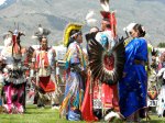
The Hoodoo Basin is laden with chippings of obsidian flakes everywhere. My friends hiked up Hoodoo Peak, a scramble on talus which I do not like. Then they easily walked the ridge about 1.5 miles to Bootjack Gap, the passage between the Crandall drainage (Papoose trail) and the Park. Large obsidian pieces were scattered all over the ridge. Hoodoo to Sunlight and Miller Creek to Crandall Creek were hard-trodden Indian trails for thousands upon thousands of years. Native peoples traveled to Obsidian Cliff (and other cherished spots for stone to work) in spring to obtain new material for atlatls and later for arrowheads. Just like the deer and elk, they ‘surfed the green’ or followed the green-up, gathering roots and plant material. In the fall, they probably stayed in Hoodoo Basin to gather pine nuts from the Whitebark Pines there.

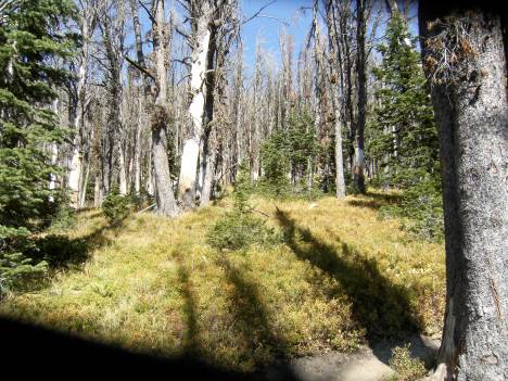
Today about 70-80% of those Whitebarks are dead, stricken down by beetles. (See photo below). The native peoples are gone, but the grizzlies are not and they are dependent on these nutritious high-fat nuts to make brown fat for the long winter. It was terribly sad to see so many dead trees, and once again made me think about the future fate of the grizzly with a delisting and subsequent hunt so close to being approved.

In addition to obsidian material everywhere, I understand there were at least forty wikiups observed by Superintendent Norris when he visited the Hoodoos or ‘Goblin Land’ as he called it.  These wikiups are no longer standing but still visible. I searched for them but was unable to find any, although I saw one that looked like a possibility. The wood would be down in a pile and very old. According to Orrin and Lorraine Bonney’s classic ‘Guide to the Wyoming Mountains and Wilderness Areas’, in 1880 when Norris and companions explored the Hoodoo area they

…found on the North side of [Parker Peak] a favorite campsite of raiding Indians with its commanding view of all approaches and handy striking distance to the high passes of Crandall Cr. He also found gory remnants of border raids–white folks’ blankets, clothes, china, bedding in & around the 40 rotting lodges. 

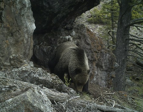
In the four days we were in the Basin, we did not see another person. The country was very dry, so this usual summer feedgrounds for elk were barren of elk and deer. Only old scat was around. We did see evidence of one grizzly bear and bighorn sheep. I also had an experience with five Short-eared Owls flying low over my head that rates among my top ten wildlife encounters.

It was an amazing journey. Worth the hard work.

DSC01440

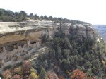
Park Boundary Line. Looking out into the Lamar Drainage

Hoodoo

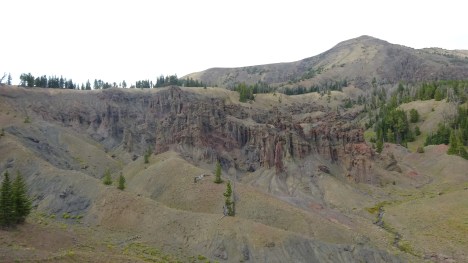
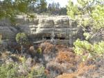
Some of the Hoodoos in the Foreground. Hoodoo Peak in the background

DSC01471.jpg

The Headwaters of the Lamar River. Smoke from fires makes the haze.

DSC01477.jpg

Dead Whitebark Pines in the Hoodoos

Delisting just around the Corner

I’ve been writing a lot of blog posts on grizzly bears for a good reason–to raise awareness that these magnificent animals are headed for delisting, and hunting, in the Greater Yellowstone Ecosystem. Grizzlies in the Northern Continental Divide will be next on the chopping block, but that’s for another round with the U.S. Fish and Wildlife.Grizzly Bear

Despite pleas from environmentalists and Native American Tribes across the West, who maintain the Great Bear is sacred in their histories, the Feds are moving forward fast at the behest of the state politicians.

Arguments on the delisting side say bears are at full capacity in the ecosystem and that is why you see them more frequently in areas near human populations. But according to David Mattson, a leading authority on bear food sources, our bears are just responding to diminishing food sources and moving out beyond the PCA boundaries.

Avalanche Peak, Yellowstone.  Dead whitebark pines

Avalanche Peak, Yellowstone. Dead whitebark pines

Feds are putting a relisting trigger at 600 or less bears. Their goal is to maintain around 674 bears. At the Spring Interagency Grizzly Bear Management Team, the report was 757 for 2014 as bears are counted when they emerge from their dens. Recently, the official count for 2015 was 714 bears, down 6% from last year. Yet so far in 2015, 59 bears have been killed by mostly human-caused mortalities–either directly or indirectly where the management team has euthanized a bear for food rewards. You can see each bear mortality here and the reasons.  That would bring our 2015 count down to 655 for 2015, already below their goal.

One might say rightly that this 2015 spring count minus this year’s mortalities does not account for new births. Yet grizzlies are notoriously slow to expand their population, as I’ve stated in other posts. Since we are most interested in females in the population, grizzlies are not ready to conceive until at least 5 years of age. Their young stay with them for 2.5 years, with a typical litter of 2-3 cubs. And with the high cub mortality, a female grizzly will, at best, only replace herself in 10 years. Grizzly front foot

If one does the math, it’s easy to see that between hunting (which will be legal but is not now; yet even now with hunter mistakes, several grizzlies are killed every year) and bears killed due to food rewards (either livestock or garbage), it will be very difficult to maintain the Feds goals that would include an official hunt.

In addition, add to this math the food pressures facing grizzlies–loss of Whitebark pines, cutthroat trout, poor berry years–plus the unknowns of climate change and one has a disaster in the making for the Great Bear.

What irks me the most is this statement:

Bears living outside the 19,300-square-mile Yellowstone “monitoring area” would not be counted toward the population goal. Similarly, bears killed outside the monitoring area would not count toward annual bear mortality caps.

This statement delivers the certainty of death for any genetic diversity in the GYE–signaling a slow decline over decades of the bears that are isolated in this ecosystem.

I’ve been interested in what happened to the California Grizzly Bear that made them go extinct so quickly. Interestingly enough, when the Spaniards arrived, they brought their cattle with them. Slowly these herds expanded into the thousands. Because the human population in California was low, few of these cows were used for meat. Mostly they were killed for their hides for leather goods. Monthly, or even weekly, they herded the cattle into killing yards, where they slaughtered and skinned them, leaving the meat to rot. Grizzlies soon learned of these cattle heaps and flocked to them. Grizzly numbers soared during the time when the Spaniards owned California because of easy increased food for bears. But of course the Spaniards had their own forms of cruelty. They roped bears for sport, pitting them against bulls after starving them for days while chained up.Grizzly mom and cubs

When the United States won the Mexican American war and gold was discovered in California, miners rushed by the thousands into the state. These men were ruthless. They killed anything that got in their way, which included Indians and Grizzlies. Within a short time, twenty years, both of these native populations had almost disappeared completely. Grizzlies became hard to find, until the last lone bear was killed in Southern California in 1908, lured into a beehive trap. It’s a terribly sad story, yet shows how fast this population can decline, from probably over 100,000 bears to almost 0 in twenty to thirty years.

Grizzly bear population in the GYE before delisting had declined to around 125 bears. After over forty years, millions of dollars, herculean efforts by many wildlife biologists and agencies, there are a little over 650-715 bears. Why is the USF&W bowing to political pressures from conservative states and rushing towards a hunt?

white bark pine bear conflicts chart

Correlation between bear/livestock conflicts and Whitebark Pine loss in the ecosystem

Mystery of the Sacred

I’d been wanting to see a series of pictographs in the desert nearby.  So the other day my friend took me out to see them.  The hike is about 6 miles round trip.  The trip out there is through flat sagebrush country.  For a long ways it doesn’t seem like there’s anything of interest.  Then suddenly the landscape shifts into deep ravines and rocky cliffs.  Near the top of a series of cliffs, a narrow valley appears.  Walking through this rift in the rocky scape, there is a palpable sense of the Sacred.  The cliffs loom high and they all have excellent writing surfaces on them.  But most are empty.  Curiously, there are natural perfect circles of a different kind of rock decorating the sandstone faces.  These natural shield shapes fool you into thinking they’re manmade.

A few official signs along the way tell you these pictographs you’re approaching are special and not to be touched or defaced.  My friend says 7 years ago there was no trail nor signs.  Since then people seemed to have discovered this place because the trail is worn and shows fresh signs of footprints and horseprints.

View from the valley

The sandstone cliffs

The valley is so quiet.  There is a somber aura here that evokes the sacred.  The high cliffs have a cathedral-like feel.  Finally we arrive at the rock with the pictographs.  My friend tells me they are fairly recent, within the last 500 years.  The rock faces east and is in the shade, which is a relief on this unusual 70 degree March day.  The paintings are very faint but you can make them out.

Look closely to see the figures

An area in the rock is chipped where the people who made these got the red coloring.

Where the red color comes from. Maybe why they chose this rock to paint

Down below, in another rocky outcropping, are a few more well preserved shields that lack the figures associated with the ones higher up.

Another painted rock much less eroded

These pictographs are sacred to the Crows.

Why are they here?  Curiously, there is no water nearby and the paintings are in a place that is isolated and hard to get to.  Although we can never get into the minds of the tribesmen who painted these, its fun to imagine what might have been going on there.  Were there several artists or just one?  Was this part of a vision quest or someone passing time in the shaded side of the valley waiting for game, or fellow travelers?  Was this a signpost or message on a well traveled trail?  I suppose it will forever remain a mystery.

Tipi Rings

I thought I’d do a short post on a few teepee rings I’ve seen.  The other day I was in Cody with some time to kill.  I’d heard there were tipi rings on the north side of the Shoshone river by Trail Creek.  A friend told me the historical wisdom-lore was that many tribes gathered there during the winter months to camp by the hot springs.  Most of those springs are now either extinct, buried under the damn, or on private lands.  In fact, the bulk of the rings, apparently 100’s of them, are on private lands going up the traditional passage of Trail Creek.

Walking along the shores of the Shoshone River (called the Stinking Water River before it was changed due to popular [and probably economic] demand)  you can still occasionally smell sulfur .  The rings are obvious, easy to pick out.  They’re incredibly close together; some even still have fire rings in the center.  Compared to the rings in other places, these looked fairly recent, maybe 150 years old.  Why?  Because the rocks are not very buried.

Cody tipi ring with fire ring in middle

Another view of several rings outside Cody

This is an excerpt from Plain Feather about the death of Crow Chief Sits in the Middle of the Land while Plain Feather was camped outside of Cody:

“About a year after the big battle on the Little Bighorn (1876), a small band of Crows went hunting from the Yellowstone to the Stinking River…The band reached the Stinking River a short distance below where the city of Cody now is located.  Here Chief Sits in the Middle announced that he was going south to a valley where there were still some buffalo left.  The other group decided to follow up the Stinking River to the big mountains where there were plenty of deer and bighorn sheep.

My family was with this latter group.  That evening we made camp at the forks of the river just above the narrow canyon where a dam is now located.  Towards evening we sighted two horseback riders galloping in our direction.  They were messengers from the other group.  They announced that the great chief and his wife suddenly became ill and soon died. They said we were to hasten over there.  It is believed that they died of pneumonia.

Immediately teepees came down and we were soon on our way.  We arrived early the next morning, just in time for the burial.  The bodies, strapped in robes, were taken to the rimrocks of the valley and put into a ledge and then covered up with slabs of rocks.  The burial mourning followed, with men and women wailing.  They recounted the many great things that the chief did for his people for many years.  At that time he was the Chief of All Chiefs, reigning over the two main bands of the Crow Nation.”**

(**Note:  In the late 1960’s, the Chiefs’ remains were relocated from nearby Meeteetsie to the Crow Agency in Montana.)

Now compare those rocks with the rocks in the rings below.  These rings were along the Bighorn River in Bighorn Canyon.  The rings are right beside the main road, which follows the ancient travel route of the Crows.

Another view along Bighorn canyon

Big Horn Canyon rings

Here are some much older rings near the town of Clark.

Clarks fork tipi rings, much older

I spent a few hours walking along the plateau near the mouth of the Clark’s Fork Canyon, an area where tribes traveled for the fall Buffalo hunt.  There are rocks galore there, and although I could pick out some rings, they couldn’t be photographed as they were very obscure and some of it might have even been my vivid imagination.  Most of the rings seemed much smaller, probably no more than 6′ in diameter compared to these larger rings.  But the setting was right–on the table above the river with a wide view of the surroundings.

I love finding these rings.  They spur my imagination and kindle a sleeping spirit.  The very soil emits stories I’m awaiting to hear.

Navajo Reservation

I slept in a campground at Monument Valley, got up early and made my way to the Monument for the 17 mile dirt road loop drive.  An incredibly magnificent, overwhelmingly beautiful and powerful place, Monument Valley is Tribal managed.  Since most tourists travel by large trailers and the dirt road is not recommended for RV’s, there are few cars on the road.  RV tourists take the tour ‘buses’.  Along the way at various locations are stalls with locals selling jewelry at ridiculously low prices. Monument Valley

Monument Valley2

Monument Valley3

Monument Valley4

I’d strung a necklace before I left of beads and 3 elk ivories I found on last winter elk kills, but it broke in Thermopolis and I lost most of the beads.  I had the ivories in my purse and asked a woman selling jewelry if she’d restring it for me.  I picked out a necklace of turquoise and beads and she restrung it right then and there with my ivories.

I picked out a necklace for $5 and she restrung it with my elk ivories

I picked out a necklace and she restrung it with my elk ivories

A new Navajo market trading post with indoor heated small stalls for artists that used to work alongside the main highway was a fine place to stroll for an hour.  I struck up a lengthy conversation with an older woman tending one shop.  She told me she did the original necklace design, while her daughter did the bead work.  As we talked her daughter, a very over weight young woman, came in briefly.  They exchanged a few words in Navajo, I said hello, complimented her beadwork as she left.

“She does excellent beadwork, and sitting all day, that’s why she’s so overweight”, my new friend said.  “She was even heavier”, she offered, “but I got her to use those patches to suppress her appetite and she lost 20 pounds.”

We talked about the weather and the wind outside.  I told her that we missed our fall and Indian summer in Wyoming, that I thought we were going to have a long, strong, winter.

“I think so too.  The Junipers are bearing heavy this year.  If you watch the plants, they’ll tell you about the coming winter.”

I told her about the past droughts in Wyoming, how water had become more scarce and only these past two years have been fairly normal.

“You too?  We are having so many problems here with water.  We’re having to start trucking it in.  No one has running water.  And our wells are full of uranium.  All our elders are dying–at 60 or 65 years old–all over the reservation, our elders are dying of cancers.  Our young people have bone problems, eyesight problems, cancers.  All from this uranium in our water from the mining that the government allowed.  They’ve closed the mines now and they want to compensate us.”

I said I thought there was no compensation for those horrors.  That clean-up, medical care–that was the ‘compensation’ they needed.

“That’s what I say.  We need medical care and they need to get rid of the uranium, somehow, in the water.  We don’t have good water, plus our water sources are drying up.”

The phone rang, she answered and I looked around the shop.

“That was my son.  My sister is in the hospital in a coma.  She was in a head-on collision last week.”  She told me the details.

We said our goodbyes.  She was such a warm, friendly person.  I left sad.  Here was a woman dealing with life’s difficulties not just on the personal level, but at a tribal level as well.  A hundred years later, the story hadn’t changed much, just the characters.  Land continues to be abused in the name of progress at the expense of these native peoples.

Indigenous peoples, old and new

Mesa Verde, Hovenweep and Canyons of the Ancients, together, all tell a story of what the Land and the Life around the Four Corners was 1200 or more years ago.  Over 30,000 people lived in the surrounding valleys and mesas, much more than today.  Their culture and architecture slowly evolving and developing, its thought they depleted their resources, leaving it devoid of trees, soil fertility, and game.  With a severe drought of over 20 years setting in, they all had to move on to greener pastures.  Sound familiar?

I really was at Mesa Verde.  Proof.

I really was at Mesa Verde. Proof.

Wow

Wow

Another dwelling site

Another dwelling site

Photo taken across the canyon.  How did they get they there, let alone build it?

Photo taken across the canyon. How did they get they there, let alone build it?

Traveling to Hovenweep, the road was incredibly beautiful.  I slept under the stars at the Monument, dreaming powerful dreams of eagles and hawks.  The Monument is primitively developed.  A walking path takes you around to each ruin.  If desired, you can drive further east to several out building ruins off dirt roads and trails.  These buildings, although constructed around the same late period as Mesa Verde (and not occupied for more than a generation or two), are architecturally very different.  Their purpose was unknown, but to me they appeared as fortresses, possibly lookout towers to alert the villages of approaching marauders as food and resources became scarcer.

All buildings were built on rock ledges overlooking canyons

All buildings were built on rock ledges overlooking canyons

My very favorite.  The boulder is gigantic its built upon

My very favorite. The boulder is gigantic its built upon

Nearby, the fairly new National Monument, Canyons of the Ancients, doesn’t even yet have literature, nor thankfully, roads.  There are over 4000 archaeological sites scattered throughout BLM managed land.  I drove up to Lowry to view one of the premier ruins, which was fully excavated in the 30’s.  These ruins are from an earlier time than Mesa Verde and Hovenweep and were clearly living quarters, with one of the three underground kivas surviving intact.

Description of ruins at Canyons of the Ancients

Description of ruins at Canyons of the Ancients

My favorite was a nearby extremely large kiva.  Clearly this kiva was used ceremonially as a gathering spot for clans and families from all around the area.  To get to these ruins, you drive a lonely dirt road through pastures and farmlands.  Nobody was there, as opposed to Mesa Verde where the walks were led by rangers with many visitors participating.

Central gathering Kiva

Central gathering Kiva

I had the wonderful opportunity to sit quietly, alone, and feel the powerful energy of that large kiva, letting my imagination fill in the gaps of wonderous gatherings of song, dance and ceremony.  That is my favorite site.

After I left Hovenweep, I headed for the Navajo reservation where I spent the night (which I’ll describe in a separate post).  I told a Navajo woman that I’d come from Mesa Verde.  We talked of these magnificent buildings and experienced builder.  I told her I wondered about how theses ancient people were able to climb down from the mesas to the buildings below (rangers say it was by handholds they made in the rock).

“Some people say they could fly.”

“That’s probably the best explanation I’ve heard”, I replied.

Blackfeet, Wolves and emblems of the Spirit

I just finished reading a wonderful little book by James Schultz.  Schultz lived with the Blackfeet Indians starting around 1880 and took an Indian wife.  He learned their language and soon, as a very young man who came out from the east coast, became accepted into the tribe as one of their own.  He, along with his friend George Grinnell, helped advocate for Glacier to become a National Park, and wrote many books about his life among the Indians and the wilds of Northern Montana. He’s providing me with a vivid sketch of life in Montana at the close of the 19th century, the final days of the free lives of the Blackfeet , as well as the last days of the Buffalo. With the recent delisting of the wolves of Montana and Idaho, and the hunts that are now taking place there, here’s a little gem of a quote from Blackfeet and Buffalo: Memories of Life among the Indians: “The big, bad wolf?  No indeed!  I once had a pet wolf, as good a friend of mine as any dog I ever owned.  But before I tell of him, I must say that, so far as I can learn, the wolves of North America never attacked human beings.  There was good reason for it:  game animals and birds, were everywhere so plentiful that they had no need to attack their great enemy, man.  The Indians have no tales about big, bad wolves.  They frighten their children into good behavior by threatening them with the bear.  Until the late 1870’s wolves fairly swarmed upon the Montana plains; their long-drawn, melancholy howls were ever  in our ears.  But lone hunters, both Indian and white, when caught out at night and far from home, lay down to sleep without the slightest fear of them.” On of the most intriguing observations about the Blackfeet is contained in the following quote: “The Blackfeet  Indians, and perhaps many others, have a peculiar habit of going up on high hills and bluffs conveniently close to camp and sitting there motionless and rigid as statues for hours.  Near the close of the day seems to be the particular time for indulging in this practice.  Why they do so is a mystery.  I have often asked them the reason, and have invariably received the reply, Kis-tohts, meaning “for nothing.”  Sometimes I have hidden myself in the coarse rye grass which grows so tall and luxuriantly in the river bottoms, and with the aid of a powerful field glass have closely scrutinized their countenances, but  to no purpose.  The expression of their faces never changed.  Their eyes had a far-off dreamy look which could not be interpreted.” Schultz speculated that maybe they were thinking about the passing away of the life they once knew.  But I have a different notion.Weather Living so close to the earth, these people keenly observed not only the animals and their movements, but the whole non-human processes–the weather, the sky, the stars. All was observed in a contemplative disposition of openness.  In their deep observations of animals, they not only learned about them for their hunt, but noticed their simplicity and ease of contemplation.   Animals were direct representations of spiritual communications and powers and so they were highly venerated and used ritually and contemplatively for various purposes.  They were emblems, doorways to Spirit.  In fact, they were a unique display of what was beyond the human, rather than lesser than human as we rate the animal world today.Deer in velvet Going and sitting on a hilltop, motionless at dusk, was a form of communion, as natural as the elk lying in the grass still and silent, or the spider who patiently sits in its web.  It was setting aside time, after the safety and the needs of the body were taken care of, to drop into contemplation.  Living with the Land as they did, there is a natural rhythm and pulse that overwhelms the body and mind when it’s still.   I believe they were just responding to that natural pulsation of contemplation that was everywhere around them, including in the animals. This is the kind of sensitivity we need today in our conversations about our ecosystems, the wolves and bears, the elk and deer and the whole animal world, including ourselves.  We are upside down.  We are not the ‘managers’.  Animals and plants are not just ‘resources’ to be exploited and managed. At one time, 100 years ago, the idea of game management was a necessity when we almost slaughtered much of our animals to extinction.  We saved our game by setting land aside, establishing hunting regulations, careful management, and educating generations of biologists. But it is a new day and a new paradigm is needed.  I don’t know the answers, but I do know where we need to begin from.   Our conversation needs to start from the assumption that all life is conscious.  That’s not an airy fairy granola eating notion.  That’s the logical application of Einsteinian physics.  And looking at animals as emblems of the sacred is a good place to start.Bison

The woman who married a bear teaches me about pine nuts

After we visited the bear cave in Yellowstone, Jim Halfpenny sat us down on a nearby log and told a story.

“When we first migrated north from Africa, ancient peoples had no idea how to live with cold, what foods to eat, how to make shelters.  The Bear was their teacher.  Native Americans had several layers in one story.  The first and simplest they might tell to the children so they would stay close and be afraid of bears.  As the child grew older, the same story would be told in greater depth revealing more teaching and wisdom.”

“This story of the woman who married a bear was told in some form all over the world where there are bears.”

Jim went on to tell this ancient story in great detail about a Chief’s daughter who married a bear, lived with the bear clan, bore him two sons and then went back to her people.  When she returned with her sons, half-bear half-human, she was now a changed woman–a wise woman with much to teach her people.

This is the story of why humans throughout time have respected and honored bears, and how it was Bear who taught Humans how to live.

I was wandering in the upper meadows this morning, watching the Clark’s nutcrackers poke their beaks in the pine cones and extract the seeds, stashing them in the pouch in their throats.  Sometimes they’d try and clean the sap off by rubbing their long beaks against the bark. Since all the cones were way high,  I looked for dropped pine nuts on the ground, possibly ones the squirrels and birds had missed.  There were lots.  But every one I opened was no good, the nut had never matured.  I tried tree after tree with the same result and I marveled at how the animals knew to let these bad ones go.  I figured that if my life depended on these seeds, I’d definitely go hungry.

When I had a big garden, I used to fight the birds for the cherries on my tree.  I tried netting, decoys, shiny objects.  But crows and jays are smart and they’d wait till the cherries were just perfectly ripe, then beat me out there.  I’d have only the leftovers.  Pine nuts seemed the same.   I began to think about the Native Americans in the Basin & Range and California traveling far and wide for the Pinyon Pine nut.  Or the Native Californians and their acorn harvests.  There were ancient tricks to this that alluded me.

I knew that when I lived in California, I used to collect Redwood cones unopened, then let them ripen by a window and all the 100’s of tiny seeds would fall out.  Perhaps…

I wandered a bit farther up the denser parts of the hillside and noticed an old middens I was familiar with.  In one of the cavities beneath the trees there was stashed 3 douglas fir pine cones, fresh this year.  And that gave me an idea.  I went back and started hunting for a middens of Limber Pine cones.  Sure enough, I found a really large one with tons and tons of fresh cones, unopened and untouched.

Limber pine middens.  There's lots more than shown and much is buried

Limber pine middens. There's lots more than shown and much is buried

Some even had the pitch gone.  There were cones on top and cones underneath.  I tried a few nuts.  These were the good ones!  These were the ones for squirrel for the long winter ahead.

The cone collector's home

The cone collector's home looking down on us raiding his middens

Then I remembered the bear story.  Bears are smart.  They do sometimes climb the trees for their beloved nuts.  But its a whole lot easier to let squirrel do the work and just raid his larder, and that’s what they do.  Bear must have taught that to the People.  That was my lesson for today.

Look close, I took this bear scat apart & there's pine nut shells

Look close, I took this bear scat apart & there's pine nut shells inside

Big Horns, Medicine Wheel, and the Pryors

Last week I took off for a few days and went to the Big Horns.  I intended to go for 3 days, but got rained out on the second evening.  I had been to the Pryors a few days before, and was quite taken with the area so I wanted to explore it more.  The Pryors are sacred to the Crow Indians.  Part of the land is on Crow Reservation and not accessible to the public.  Some of the mountains are in Montana, and some in Wyoming, with a section of it reserved for Wild Horses.  The entire area is considered a Wilderness Study Area, which means that it’s pending designated Wilderness.  Rarely visited, its a special place.  There are some old uranium mines there and mining claims.

Since Day 1 was really hot, I decided to backtrack to the Pryors and head first for the Big Horns.  My main intention was to go to The Medicine Wheel.   This is a holy site for many Plains Indians tribes.  Its a place of pilgrimage.

Entrance to Medicine Wheel

Signage at the site notes that some people can prepare for a year before making the trip.  A young Forest Ranger was stationed at the Wheel to make sure there was no vandalism, and if Native Americans wanted to go inside, he had a key.  When ceremonies are conducted, the site is closed to tourists.

He told me that years ago, before there was such tight control, tourists (not Native Americans) would take home rocks from the structure as souvenirs. In fact, he said, the height of the circle of rocks was 2′ or 3′ taller than it is today.

I was reminded that in Uluru, tourists sometimes take home pieces from the sacred site.  There is a large collection of rocks that were mailed back to Uluru because tourists went home and felt they were brought bad luck, bad karma, or whatever, from taking souvenirs from the site.Medicine Wheel signage
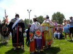
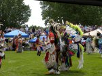
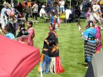
I circumambulated the Wheel three times and left a small gift at the East facing entrance.  Its a wonderful and mysterious place.  Some say it was constructed by Sheepeaters.

From there I took the Jaws hike down a beautiful canyon opposite the Wheel.  I saw several moose and deer with their antlers in velvet.

The jaws hike

The jaws hike

Along the canyon hike

Along the canyon hike

The next day I went to the Pryors.  It was overcast and drizzling, perfect weather for hiking in this exposed country.  The Pryors were an ancient Indian route through the Big Horn Canyon.  There are many spots right along the main road of the Recreation Area with teepee rings.  Instead of going along the main road, I took a 4×4 track.

Pryor Mountain Wild Horse RangeThe Pryors

Koda matches

Koda matches

On the way out I encountered a mama wild turkey on her clutch of eggs.Wild Turkey on eggs

Wild turkey eggs

PowWow in Cody

This weekend is the Powwow at the Buffalo Bill Historical Center in Cody.  It was my first powwow, if you don’t count the one I stumbled upon when I was 17 in Montana, and it was great fun.  All the colorful costumes, dancers from old to young in all different categories of dance, from fancy to traditional, competing.  I had no idea what a powwow was.  It is like a gathering of family, friends, and different tribes, dancing and having fun.  We should all dance more.

Here are a few highlight photos.

Dancer in preparation

Costumed dancers

Moccasins