• BOOKS ABOUT WILDLIFE AND HEALTH

  • My latest book available in paperback and eBook formats

  • Available from Amazon paperback or Kindle

  • Updated w/double blind study results. Ebook or paperback

  • New updated edition available NOW!

  • Recent Posts

  • Tracking Footprints

  • Archives

  • Top Posts

  • Pages

Thomas Jaggar visits the Absarokas in 1893

Arnold Hague began the first detailed survey of Yellowstone National Park and surrounding areas in 1883 .  Thomas Jaggar worked as an assistant geologist under Arnold Hague.  In 1893 and 1897 the lands just east of the Park were the territory to be surveyed, most of which was within the Yellowstone Park Forest Reservation [the forerunner of the National Forests].

Jaggar in Yellowstone Park's death gulch where he discovered 8 dead bears killed by the noxious gases.

Jaggar in Yellowstone Park’s death gulch where he discovered 8 dead bears killed by the noxious gases that accumulate in the drainage.  These bears might have been attracted by the smell of elk that had succumbed.

I’ve been reading Jaggar’s diary of the Sunlight/Crandall area where I live, as well as looking at his photos.  His survey notes include geology notes and other tidbits.  He developed his photos right in the field.  Interestingly, Jagger reports seeing antelope in my basin.  There are no antelope here today, yet there is a local geological feature called Antelope Butte.  What happened to them all, and why they haven’t reestablished themselves is a mystery, for there are plenty of antelope in the basin around Cody, as well as the Lamar Valley nearby.

By 1893, bison had been exterminated and there were already a few cattle ranchers here.  Jaggar reports riding over an ancient local Indian connector trail, entering the valley and seeing “sagebrush, elk, buffalo, sheep & horse skulls and horns.”  Instead of bison, grouse and cattle were in the Trail Creek canyon.  Today cattle don’t run there and I’ve never seen grouse in the sagebrush area.

I hiked to a point where Jaggar took a panorama of the valley in 1893.  In the early 20th century, fire suppression became the doctrine of forest management.  But Jagger’s photo was taken when nature was still allowed to take its course.  In Jagger’s photo below, it appears the trees in the foreground were conifers killed in a fire.  In my photo below Jaggars, I could barely find a angle that I could take the photo without trees obstructing the view.  But my photo is taken from basically the exact same location.

1893 Photo

1893 Photo

2014 same location

2014 same location

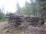
Aspens are the first trees to regenerate after a fire.  A few years ago I accompanied Larry Todd, a local archaeologist, to survey some old wikiups [Sheep Eater Shoshone houses] in one of the small drainages off the valley.  Although these wikiups were standing in the 1970s, cattle feeding on the Forest Service grazing allotments liked to rub against them, and so knocked them over.  By examining the logs, Larry was able to determine the age of the wikiups was 300-400 years old, and surprisingly, these logs were all aspen.  As you can see from the photo below [wikiup logs are in the pile], the forest is all conifers now.  Aspens live for only 80-100 years.  The next in the succession in this dry area would be Douglas Firs, which can live for many hundreds of years, suppressing any new aspen growth.  Without natural fires, the forest will be dominated by conifers.  So this forest used to be all aspens, and probably was a much wetter environment.  Larry pointed out that the climate 300 years ago was different here.  This wikiup sits are the confluence of two seasonal creeks but at that time these creeks might have run year-round.

300 year old wikiup standing till 25 years ago when destroyed by cattle

300 year old wikiup.  Pile of logs are the remains of an aspen wikiup.


Big Horns, Medicine Wheel, and the Pryors

Last week I took off for a few days and went to the Big Horns.  I intended to go for 3 days, but got rained out on the second evening.  I had been to the Pryors a few days before, and was quite taken with the area so I wanted to explore it more.  The Pryors are sacred to the Crow Indians.  Part of the land is on Crow Reservation and not accessible to the public.  Some of the mountains are in Montana, and some in Wyoming, with a section of it reserved for Wild Horses.  The entire area is considered a Wilderness Study Area, which means that it’s pending designated Wilderness.  Rarely visited, its a special place.  There are some old uranium mines there and mining claims.

Since Day 1 was really hot, I decided to backtrack to the Pryors and head first for the Big Horns.  My main intention was to go to The Medicine Wheel.   This is a holy site for many Plains Indians tribes.  Its a place of pilgrimage.

Entrance to Medicine Wheel

Signage at the site notes that some people can prepare for a year before making the trip.  A young Forest Ranger was stationed at the Wheel to make sure there was no vandalism, and if Native Americans wanted to go inside, he had a key.  When ceremonies are conducted, the site is closed to tourists.

He told me that years ago, before there was such tight control, tourists (not Native Americans) would take home rocks from the structure as souvenirs. In fact, he said, the height of the circle of rocks was 2′ or 3′ taller than it is today.

I was reminded that in Uluru, tourists sometimes take home pieces from the sacred site.  There is a large collection of rocks that were mailed back to Uluru because tourists went home and felt they were brought bad luck, bad karma, or whatever, from taking souvenirs from the site.Medicine Wheel signageI circumambulated the Wheel three times and left a small gift at the East facing entrance.  Its a wonderful and mysterious place.  Some say it was constructed by Sheepeaters.

From there I took the Jaws hike down a beautiful canyon opposite the Wheel.  I saw several moose and deer with their antlers in velvet.

The jaws hike

The jaws hike

Along the canyon hike

Along the canyon hike

The next day I went to the Pryors.  It was overcast and drizzling, perfect weather for hiking in this exposed country.  The Pryors were an ancient Indian route through the Big Horn Canyon.  There are many spots right along the main road of the Recreation Area with teepee rings.  Instead of going along the main road, I took a 4×4 track.

Pryor Mountain Wild Horse RangeThe Pryors

Koda matches

Koda matches

On the way out I encountered a mama wild turkey on her clutch of eggs.Wild Turkey on eggs

Wild turkey eggs

Only the wind sang

Yesterday I met Larry Todd over at the Dead Indian Campground site.  Larry is an archaeologist working mostly in the Greybull area.  I contacted him several months ago because he was in charge of the dig in the ’80’s at the Bugas-Holding site, a Shoshone winter campground 400 years old.  I had many questions, and Larry graciously invited me to walk around the Dead Indian site with him after he finished an outing there with Cody Middle School.

Next to a creek and protected by mountains, Dead Indian is a 5000 year old winter campground site that had continuous use.  It is one of three archaeological sites in the Cody area on the National Historic Landmarks, the other two being the Horner site and Mummy Cave.  Larry explained that some areas were early Archaic, some middle, and some late, depending upon the topography.  The lower levels around the creek were the latest periods.  He said that when they began work, the entire area had so many artifacts they had to choose specific areas to concentrate on.  The work was done in the 70’s, before he was around to participate.

Topography of the mountains around Dead Indian Historic Landmark

Topography of the mountains around Dead Indian Historic Landmark

We walked over to a large plateau, an early Archaic period.  Larry painted a picture of a campsite with upwards of several hundred people, living in family groups–a small Wyoming town so to speak.  People living in pit houses that came here winter after winter to hunt the game that was plentiful.  Mostly deer and sheep were killed at this site.  Their tools were made from local materials, sharp and new in the fall, but dulled by spring through continuous retooling.  By spring it was time to gather and trade for new raw materials for arrowheads and other necessities.

Looking into Dead Indian Valley

Looking into Dead Indian Valley

In this early Archaic period, the big game were gone and more intensive hunting and gathering was necessary  for the equivalent quality of nutrition.  People were settling down for longer periods and returning to the same sites. Deer, much easier to herd and more predictable than elk, were the main large food source, along with sheep.  At Dead Indian, large ceremonies were conducted in honor of this food source.

Larry told me that the Bugas-Holding site was like a still image.  It was used for the duration of one winter only.  Here at Dead Indian the story was more like a novel, with many chapters.  He thought Dead Indian might have gone through periods of heavy use and lighter use.  Having been used continuously for so long, probably many different periods of histories and stories had taken place here.

Slot Canyon in Dead Indian

Slot Canyon in Dead Indian

Dead Indian Creek and slot canyon

Dead Indian Creek and slot canyon

Larry talked about the interactions between the land and the peoples.  By the time Lewis and Clark appeared–what we mark as the first interactions with white men in the West–many Native Americans had already been decimated by disease and the landscapes they had shaped were already changed.  The wilderness white people saw at that time was imprinted in their minds as what the land always was. But really it was just a snapshot.   To live winter after winter in these mountains takes an enormous amount of religious, and traditional, training and knowledge.  These practical skills are a cultural phenomenon, passed on generationally.  Thousands of years of accumulated wisdom had been decimated through disease and warfare in a short time.  Larry thought that by the time Lewis and Clark came, enough of that knowledge had been wiped out so that fewer and fewer people could live in these mountains.  The land itself had changed in response. What white men saw as wilderness, was a degeneration of the land through non-use.

Our idea of wilderness is non-use.  Looking east across Yellowstone lake in winter

Our idea of wilderness is non-use. Looking east across Yellowstone lake in winter

I mentioned that in Australia, after 60,000 years of aboriginals working the land with fire, botanists weren’t sure if the plants had adapted to fire because of human intervention or vice versa.  He told me that Bison antiquus was a good example of that here.  Bison antiquus, the ancestor of our modern Bison, was much larger than today’s Bison and died out about 10,000 years ago.  The theory goes that the smaller, lighter, and more streamlined buffalo could run faster, giving them a decided advantage from the top predator, man.

Modern day bison

Modern day bison

As we walked around the site, Larry bent down and showed me how almost every square inch, to the trained eye, contained evidence of habitation.  Chippings from chert, quarzite, chalcedon, pieces of bone, a sheep vertebrae–all this he found within a few square feet.  I hadn’t seen anything until he pointed it all out.  I could feel the vibrancy of the culture once there.  We talked about fire and how it can clear a site. He said that a fire can come through, clear all the duff and topsoil, and the site is exposed just how it was left thousands of years before, including fire pits, chippings and all.

“Its like someone’s found an original map or book that’s going to unlock all these new secrets.  But before we even have a chance to organize and fund an archaeological expedition, the looters are there within weeks, days.  The site is stripped and the information is lost forever.”

We walked back to the road while Larry told me a story about Bison, his specialty.  He said that Native Americans didn’t always use all the meat.  It was common to just take the prime parts after a kill.  One time he was talking with a Blackfoot elder about ancient hunting methods.  When he came to the part about how they left parts of the kill, a student listening nearby said “They wasted parts.”

“Would you take all of it?” asked the elder.  “Would you be that greedy?”

The student replied, “I wouldn’t waste anything.  I’d take it all.”

“You whites are so greedy.  You wouldn’t leave any meat for your brothers–the wolf, coyote, raven.”

I looked back at the site.  Only the wind sang.  I tried to imagine what once was.

The wickiup

Last week my friend W__ and I hiked up almost to the ridgeline on the steep slopes across the river from my cabin.  That entire hillside used to be owned by Doc Firor, the original owner of my cabin.  Unfortunately, it had been sold after he died and divvied up into  6 acre parcels with cabins on it.

That is the south facing side and is basically granite, which means its mostly treeless down below and there’s very little water run-off.  In fact, over these last 10 years of drought and climate change, many of the springs have dried up.We hiked almost to the ridgeline

W__ had been up there several years ago with a local and found some evidence of Sheepeater houses.  “My friend pointed to some old logs and said ‘these are them’.  I really had to use my imagination.”

The hike is tough and pretty much straight up.  You climb through a series of level meadows followed by steep ascents.  The first 2/3 consists of scattered limber pines and doug firs.  W__ couldn’t remember exactly at what height he had seen the ruins, so we wound up climbing almost to the base of the cliffs.  Several levels below the cliff-line is open forests with stunted trees.  We were right below the cliffs

Most of the time we followed deer or elk trails.  We would stop and inspect a level area, then move on to higher ground.  At one point I spotted a tiny obsidian flake.  I have no idea how I found it amidst all the duff and debris.  We joked that the obsidian flake and the crow feather we found meant we were ‘hot on the trail’.

Pretty soon, after not encountering any sheepeater evidence, I forgot all about looking for ancient artifacts and enjoyed the forest.  The rolling gurgle of Sandhill cranes in the distance, migrating in, spoke of winter breaking.  The views were magnificent as we were about 2,000 feet above the valley.The view was magnificent
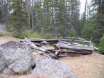
After a lunch break we began heading back.  We descended slightly down to a lower yet still forested level that we hadn’t inspected.   Suddenly W__ spotted some old timber.  In a flat clearing, butting up against the hillside, was a distinct squared off area constructed of ancient logs.Sheepeater hut

Another view

I looked around and noticed that behind me was access to the cliff areas, while in front was a complete view of the valley.Access to the cliffs behind

Site looks over the whole valley

A spring used to run nearby that’s now dry since the homeowners below diverted it for their own use.   Several hundred yards directly east we encountered an opening to a gully that ran east/west.  We walked along the top of the unusual drainage, now full of snow.  It was long and wide, narrowing into a natural boxed trap.  I could almost imagine the Sheepeaters driving Bighorn into the small canyon where they’d easily be trapped and killed.  Probably this dwelling, I thought, was just a temporary shelter used in winter.  The haul of the kill back down the valley to the Bugas-Holding site, not exactly nearby, must have been tough.  The Sheepeaters used dogs with travois to do a lot of their carrying.

The one thing that made me uncertain was that all the pictures I’d ever seen in books had Sheepeater ‘houses’ as teepee style structures, with logs piled on top of logs.  This was definitely a square structure.

When I returned I showed the photos to my old neighbor JB who grew up in the valley.  He further cast doubt on the sheepeater theory as he thought the structure looked more like an old bear trap.

“There’s a tree in the middle with only one exit.  They’d tie a horse as bait for the bear.  I bet that’s what that is. The Indian houses were teepee log structures.”

Somehow I couldn’t imagine those old homesteaders climbing way up the mountain to bait a bear.  “Heck”, I thought, “if I was going to bait a bear, I’d do it in the drainages down below where they usually hang out. And I wouldn’t have to trek way up here.”  W__ thought it was all wrong.  “No”, he said, “the logs are really old.  That’s a sheepeater’s structure.

Several days later I decided to take another look.  I found an easier route from the road.  Although not as much climbing was involved because I started higher up, I had a lot more ground to cover.  Taking another look at the structure, it had absolutely no exit.  There were four complete sides.  And the dead tree inside was too young compared to the timber used to construct the dwelling.  Still I had no way of being certain.  I don’t have the expertise and there’s always the unknown factors.

On my way down the hillside, I ran into some locals.  The woman was from the University of Wyoming extension.  They knew the area and knew of the wickiup.

“Several years ago that was discovered by one of the ranch hands doing some work on the stream.  He called George Frison who came out and looked at it.  Frison said it was the real thing–a Sheepeater dwelling.  It used to be more intact, had more height to it.  It’s deteriorated since we first saw it.”

I had to wonder how the structure had deteriorated so fast over the last 20 years compared to the fact that its probably at least 150 years old.  These are special sites and need to be watched over.  When the ’88 fires came through here, the forest service was cutting break lines.  If it hadn’t been for one of the locals pointing out a sheeptrap to them, they would have cleared it completely.

Fire is destroying the evidence of these ancient peoples.  There is a concerted effort going on to find and GPS as many of these sites as possible before they are destroyed.  Interestingly, although fire will destroy wood structures, it also clears duff and can expose artifacts buried below.  The Boulder Basin site is a perfect example.  It had been explored since the 1970’s.  Although sheep traps were evident, Archaeologists thought that the sites had been cleared and looted because little other cultural evidence was found.  After the fires, the site was re-visited and hundreds of projectile points, bone fragments, stone implements, and other important artifacts were uncovered, some simply scattered above the burned ground.

These are Americas’ Acropolis, our Pyramids.  They stir our imagination and resonant with the collective unconscious of humankind.  I see these old timbers and dream the dream of what it might have been like to be living here so long ago; to be dependent on one’s community and the earth; to be a wanderer, a hunter-gatherer; to be so intimate with the natural world.  These are important places, for us, for our children, for all mankind.

The First Peoples here

Greater Yellowstone Ecosystem has two premier archaeological sites, both on the eastern side.  One is Mummy Cave located between Cody and Yellowstone; the other is Dead Indian Campground, located along Chief Joseph Scenic Highway north of Cody.  Mummy Cave is a well-preserved site showing evidence up to 9000 years old.  It is well-known and much talked about.

On the other hand, Dead Indian site is difficult to find much information about.  The site butts up against the road, near the Dead Indian Campground.  It was discovered when someone noticed bones and artifacts slumping into the creek and a dig was lead by George Frison of The University of Wyoming beginning in 1969 and continuing through 1971. According to Frison’s Survival by Hunting, the Dead Indian site is around 4000 years old and probably a large winter campsite.

Another premier site nearby is the Bugas-Holding site.  The area is meadow, aspens, and next to the creek.  This site also was a large winter campsite where both Bighorn Sheep and Buffalo were taken.  Bugas-Holding site

In order to find out more about the Dead Indian site, I went to the Cody library and was lucky enough that they had a copy of the Wyoming Archaeologist from the 70’s when the site was excavated.  The local chapter had done the dig with help from Frison.  The frayed paperbound copy was the technical report of the findings.

Walking around the site now, my untrained eye would never know there had been a dig.  The teepee rings are no longer visible.  The only evidence I saw was a single small 1/8″ size obsidian chip.  The area though, is a perfect campsite.  It has a fairly large and flat meadow right near the creek.  It is east enough of the Absarokas that the snow accumulation is less than farther up Dead Indian drainage.  It is protected from wind and has areas for lookouts.  And it is along a major route through the Park and into the desert below.

In the dig they found antlers of mule deer laid out in ceremonial fashion.  A skeleton of a small child was uncovered.  Over 500 projectile points and hundreds of stone tools were unearthed.  It seems that mostly what these people killed and ate were mule deer and mountain sheep.  Even though they lived here during the winter, few elk were uncovered which suggests the populations of  large mammals was very different then.  George Frison thinks hunting was done singly or in a group, rather than using large scale trapping.

Just around the corner over at Bugas-Holding, mostly Buffalo and sheep were found.  The sheep were probably taken in traps right near the site.  The site is on private property but a short jaunt over the hills and there are numerous sheep traps, close enough to bring back kill to the campground.  An easy walk above the site and you can view the entire valley, east to west; a perfect place for a lookout.  Looking up the valley from the siteLarge obsidian flaking sites are around these hillsides.  It seems that this site was later than the Dead Indian and they did use large scale trapping.

George Frison wonders, and so do I, why these peoples would overwinter in and around 7,000′, when they could have easily gone down to the Big Horn Basin at around 5000′ where there is less snow cover.  He suggests the abundance of winter hunting.  You also have to wonder if the climate was different then as well.The creek in winterAs I find out more about what went on in this area east of Yellowstone, I’ll let you know.  To imagine this was a major route through the Park, and a large scale occupation area–well, its very quiet here now.  Few people live here year round; most choose to live in the lower elevations nearby.   People hunt here now, but the people who hunted here in the past also did ceremony to their prey.  When I happen to find a small piece of evidence, like a sheep trap or a piece of obsidian, there is a bit of wonder and mystery about it–and sadness.  Some principal piece that went on here for thousands of years is gone forever.

The Thompson Cabin

A few summers ago,  my cabin’s original owners’ son, T___, came visiting from West Virginia.  He is a surveyor and had some maps of the Clark’s Fork Canyon.Clarks Fork's Canyon with Sunlight Falls

“There’s a box canyon over here”  he pointed out, “with an old cabin sitting by the river.  They call it ‘the Thompson Cabin’ cause old man Thompson lived there in the 1880’s.  Well, that’s the story I heard.  They say he trapped and made moonshine.  That once a year he took his furs on his mules, and went over Dead Indian pass into Cody.  He’d take them to the trading post and while they decided on what to give him, he’d go drink his money away.”

T___ didn’t have time to hike to the cabin, but he gave me a good idea where it might be.  Following his map, the box canyon was easy to find.  The cabin sat on the other side of the river, which was low enough to cross by way of deadfall.  Thompson Cabin

The cabin itself was awfully small.  The windows were gone of course, but the frames were nailed with square nails.  The locals and kids had camped and left bottles there over the years, but a depression still marked the old root cellar.  It was just hard for me to imagine living in such a small little box.  It gave me great respect for those old-timers.Square nails in the window frameDepression at the back is the cellar

Thompson had situated his cabin on the south side of Dead Indian Creek which made sense, because in winter and spring the creek would be hard to cross.  I’m not exactly sure the path he took his horses or mules, but I could scramble up the hillside and be close to the main road.  Of course, there wasn’t a road then, but the road that’s there now follows fairly closely old Indian trails over the pass to Cody or up towards the Park.

I told my friend JB about it.  He’s the old man who grew up in the valley.

“Thompson, I remember him from when I was a kid.  My grandfather used to go visit him.  Thompson would invite him for dinner.  One day he was helping wash the dishes, when Thompson took the dishrag and blew his nose in it. ‘Time to leave’ my grandpa said.”

“Thompson had a big garden there.  He grew potatoes, and carrots, watermelons and lettuce.  Then he’d take his fare up to Cooke City to sell.  Took him two days by horseback.”

Sometimes I run into old cabins.  Once I ran into one in the Beartooths at Stockade Lake, probably an old forest service cabin.  There’s some at the end of my valley that were old mining cabins in the early 20th century.  I know the old ones in Yellowstone are usually destroyed when they’re found.  But the Thompson cabin held an interesting history for me, and at least one that I heard some yarns about.Old miners cabin from early 20th century

I like the area the cabin is in and hike there frequently. Nearby, I found a rose quartz vein and an eagle feather.

On the other side of the river, there’s a small flat open plateau, and that’s where the magic resides.  Its sunny and peaceful.  I like to go over there and explore the cliffs and look under the trees.  Then I heard from another local that the plateau is an old Indian winter campground and he’d found arrowheads there. I supposed I like it for the same reason the Sheepeaters liked it and old man Thompson liked it.  Besides being protected from the wind and snow, having year round water, safety from enemies,  good trapping and fishing, easy trail access– it just has a good feeling.

The bighorn sheep of Little Bald Ridge

The ranch manager told me yesterday that the three wolves who were shot last summer for cattle predation were terribly mangy.  Mange is the latest big problem with wolves in the GYC.  Mange is a mite that burrows into the skin of an animal, causing it to scratch.  It doesn’t kill the wolf, but in a harsh winter they can die with the thin coat.  I heard that mange was brought into this country early last century to kill coyotes but I haven’t been able to verify that.  One of the interns told me he thought that if a wolf can make it through one winter with the mite, he’ll do o.k. after that.  Maybe some kind of resistant or tolerance occurs.

Last summer I did have a fairly close encounter with a wolf.  That black wolf was beautiful and fluffy; no mange there.  I was walking through a lightly wooded area off-trail when my dog stopped about 8 feet in front of me and stared at something in a shallow gully off to my left.  The whole scene took place so fast I barely had time to register what was happening.  I looked to my left and saw a smallish black animal, about the size of my dog but fluffier, about 12 feet away.  I thought it was a small black bear.  By the time I realized it was a wolf (about a millisecond later!),  my dog was gone.  Usually I carry an electric zapper on my dog for just these occasions, but the zapper was still in California from my move.

I think my incessant screaming, and the fact that that wolf was a lone yearling, scared that wolf so much that she ran off, but not before she had thrown up the contents of her stomach which I found later after my dog returned and I had calmed down.  After what seemed like an eternity, Koda came prancing back, with a shit-eating grin on his face.  In the span of those few seconds, I had both surrendered to the idea that my dog might never come back, and if he did come back, decided he was going back to the trainer’s for some additional dog-to-dog training.

Wolves kill other canines in their territory.  Doesn’t matter if its a coyote, another wolf, or a dog.  They don’t eat it, just really tear it to pieces.  Being a dog owner in wolf country means you have to be responsible and watchful.  The ranch hands at a large ranch across the river told me that the winter is really the time they need to be careful.  Although they have wolf activity there year round from the Beartooth Pack, their property is full of elk in the winter and the wolves come down more and the nights are long.  Many of the wealthy ranches here have heated kennels for their dogs.  She told me a story that last winter the dogs were out of the kennel on a cold winter day.  Luckily she was working nearby because she looked over and there was a small pack surrounding their three dogs.  She ran over, made a big ruckus, and scared the wolves away.

Another local told me he was hiking with his five year old Black Lab.  The Lab ran over and behind a large bush where he was attacked by two wolves.  Luckily, the dog lived.  But the next year they were hiking off-trail and the lab started whining and came close to this man’s leg.  In the woods about 50 feet away, several wolves ran through.  Guess that dog learned a lesson.

Yesterday I planned to hike up Little Bald Ridge where there’s always sheep.  As I drove down the dirt road, I could see tracks of two large wolves that had run down the road early morning. Climbing up Little Bald Ridge They always like to use the thoroughfare of that spot in the valley to go between two ridges.  As I drove bye, I noticed one of the cows just had a new calf.

Bighorn Sheep are always up on that ridge.  I tried hiking up there earlier, but the wind and snow got to me.  Today was warm and windless though and some of the drifts would have melted.  As I hiked up to the buttes, I stopped 2/3 up in a small high meadow that looks out over the entire valley below.  No wind, the silence was incredible.  A herd of elk came through the trees farther up and stopped to watch me.  They’re always skittish.  They decided I was something to be afraid of and ran up the mountain and out of sight.

The hike isn’t Annapurna, but its a wind stopper for sure.  Its up, up and up and I hoped that when I got to the top the sheep would be in sight.  As I rounded the bend, there they were.  I kept counting, and then kept counting some more.  There were about 2 dozen sheep.  Mostly young and ewes, but I saw one nice ram.  The ewes kept watch while the ram lazed away–typical!  Bighorn are really ‘cute’.  Every time I go up there, they’re so curious.  Unlike the elk who always just run, the sheep stare and stare the closer you get.  If I didn’t have the dog, I suppose I could almost have walked up to them.

Bighorns depend on their elders to find their wintering grounds.  This small herd is right near the stone sheeptrap that I wrote about the other day.  Of course, to be called Sheepeaters, there had to be so many more sheep around here.  My understanding was that this country was thick with sheep, not just 2 dozen.  The interesting thing is that if you look around, there are plenty of exactly similar buttes right nearby where those sheep could have been.  But every year during the winter, this is the butte they go to.  You can count 100% on finding them there.  To me, this means they have an ancient honing device in them.  They must automatically go to the same forage that their ancestors went to.

I had been wondering for some time what happened to all those sheep.   After some research, I found Bighorns had no immunity to the diseases domesticated sheep carry.  Domesticated sheep grazing on open pastures and private lands were and still are, wiping out the Bighorn population.  And to the Bighorns, domesticated sheep just look like sheep; and being so friendly, Bighorns like to mix it up, unlike wolves.

The Bighorns on Little Bald had several yearlings, but I only saw one baby, at least so far.  After a while they got used to me and Koda, and went back to their business of eating.  The ram finally got curious enough to stand up for me to view him.  The baby ran with his mother.  The yearlings stayed in a small group with some ‘nurse ewes’ who watched over them, nuzzling occassionally.  I would have stayed for hours and watched them, but it was getting pretty cold and windy up there on the ridge.

The Sheepeaters

One of the interns gave me a book of Robert Service poems.  Oh, how I like so many of them.  Here’s a few verses from one of my favorites called ‘The Spell of the Yukon”

The summer — no sweeter was ever;
The sunshiny woods all athrill;
The grayling aleap in the river,
The bighorn asleep on the hill.
The strong life that never knows harness;
The wilds where the caribou call;
The freshness, the freedom, the farness —
O God! how I’m stuck on it all.

The winter! the brightness that blinds you,
The white land locked tight as a drum,
The cold fear that follows and finds you,
The silence that bludgeons you dumb.
The snows that are older than history,
The woods where the weird shadows slant;
The stillness, the moonlight, the mystery,
I’ve bade ’em good-by — but I can’t.

There’s a land where the mountains are nameless,
And the rivers all run God knows where;
There are lives that are erring and aimless,
And deaths that just hang by a hair;
There are hardships that nobody reckons;
There are valleys unpeopled and still;
There’s a land — oh, it beckons and beckons,
And I want to go back — and I will

Its interesting how one can feel a place.  Up the dirt road towards Yellowstone, there’s an area that just feels good.  The wolves like to den there, the Bighorn sheep hang on the cliffs there, and the Sheepeaters had winter camp there for 5000 years.  Keep going farther up that road, about 20 miles, closer to Yellowstone, and the feeling changes.  Something about that area always feels ominous to me.  As the valley narrows, the Absarokas close in.  Volcanic in nature, the mountains tell the story of fire and ice with their knife edge ridges and slopes of scree.  I’m always a little uneasy up there.  Its beauty and wildness belie ancient and ominous secrets.  I’m wondering ‘What happened here?’

But my story is about the area that feels good.  Last summer I spent a long time looking for a ‘sheep trap’.  I’d been told about one that was a small cleft in the rock face.

W___ had told me there was a sheep trap up in the timber, yet everytime I looked I couldn’t find where he said it was at.

Sheeptraps were used by the Native Americans who lived around here.  A sub-group of the Shoshones, they were named Sheepeaters because their primary diet consisted of Bighorn Sheep.  They made the finest bows out of horn, used no horses, and went back and forth into the Park.  These sheeptraps were one of their ways of hunting.  Usually placed along a game trail and on the downhill slope (Sheep always see what’s coming from below, but never tend to look up for danger), the traps had drive lines of dead wood that lead to a pen.  Once in the corral, then animals were usually bludgeoned to death.

I spent many days looking for the trap.  My mistake really was to go on W___ ‘s advice.  There WAS a trap he knew about up there, but it wasn’t the natural rock formation one.  He’d only been there once, and since he didn’t know this area well (he’d gone with another person who did) his directions were weak.  One time I hiked way up the mountain through several meadows.  I was tired and it was getting late. Turned out I was only a few hundred yards from the trap in the woods.  But when W__ did take me there later on, I didn’t feel so badly, for I talked with several hunters who’d walked right by the trap and never saw it.

Partially buried sheep trapThe wooden trap was awfully small, but when you looked closely, it was obvious that it was buried deep.  The wood was old and it was amazing the construction was still intact.

I knew that there must be another trap somewhere else.  I decided to walk along the cliffs farther down the meadows.

Fall was in full force and the days were short.  One afternoon I took a few hours and hiked up to the bottom of the cliffline.  I walked its edge.

The view was fabulous from up high and I stopped to investigate a natural arch.  There was nothing inside but packrat remnants.

Farther along the wall, I came to an extremely narrow notch in the wall.  Some unknown force drew me to climb up it to the landing above to investigate.  I hesitated.  The light was getting low, I was running out of time, and this seemed like just a curious sidetrack.  But I couldn’t resist.  I scrambled on all fours through some snow and debris up the cleftt to small flat area above.  Walking around on top of the rock, I noticed a second but larger cleft between two gigantic boulders.  The boulders narrowed sharply and a tree was growing at the base.  It was a curious natural formation.  A few pieces of wood and debris were inside.  I looked around but saw no evidence of any drive lines.

I climbed back down the notch and continued making my way along the wall.  In short order I came upon a dry creek bed and an old game trail that led to the landing up above.  It was then that it hit me–That cleft WAS the pen, just a natural one.  It was so obvious.  I raced back up the ravine as the sun was starting to set.  Sure enough, the game trail passed a few hundred feet above that cleft.Looking from above

And now I noticed random wood above the cleft, probably strewn around for the last hundred and fifty years, once used as the drive line.  The whole setup seemed so ingenious to me, with the minimal expenditure of energy.  The ancient game trail right there, the Sheepeaters waiting in the timber above, the natural pen below.  If you walked from the cliff line below, you’d never notice this pen because of the tree and a good amount of debris placed there to block the exit.

I sat down at the top of the rock and watched the setting sun.  I marveled at how by trusting a feeling I found this place.  And the moment of ‘Ah ha’ that came from the inside out.    It was getting cold now.  But I took a little time to sit and say ‘thank you’ to whatever bought me here.