• MY BOOKS ON WILDLIFE, GARDENING AND MORE

  • The Wild Excellence

  • True stories of wildlife encounters around the Greater Yellowstone
  • Award winning eBook on Decomposed Granite, tips, how to's, what to watch for
  • Children's book. True stories of a dog and wolves. In a dog's voice
  • Written for dry Mediterranean climates in California, north and south

Only the wind sang

Yesterday I met Larry Todd over at the Dead Indian Campground site.  Larry is an archaeologist working mostly in the Greybull area.  I contacted him several months ago because he was in charge of the dig in the ’80’s at the Bugas-Holding site, a Shoshone winter campground 400 years old.  I had many questions, and Larry graciously invited me to walk around the Dead Indian site with him after he finished an outing there with Cody Middle School.

Next to a creek and protected by mountains, Dead Indian is a 5000 year old winter campground site that had continuous use.  It is one of three archaeological sites in the Cody area on the National Historic Landmarks, the other two being the Horner site and Mummy Cave.  Larry explained that some areas were early Archaic, some middle, and some late, depending upon the topography.  The lower levels around the creek were the latest periods.  He said that when they began work, the entire area had so many artifacts they had to choose specific areas to concentrate on.  The work was done in the 70’s, before he was around to participate.

Topography of the mountains around Dead Indian Historic Landmark

Topography of the mountains around Dead Indian Historic Landmark

We walked over to a large plateau, an early Archaic period.  Larry painted a picture of a campsite with upwards of several hundred people, living in family groups–a small Wyoming town so to speak.  People living in pit houses that came here winter after winter to hunt the game that was plentiful.  Mostly deer and sheep were killed at this site.  Their tools were made from local materials, sharp and new in the fall, but dulled by spring through continuous retooling.  By spring it was time to gather and trade for new raw materials for arrowheads and other necessities.

Looking into Dead Indian Valley

Looking into Dead Indian Valley

In this early Archaic period, the big game were gone and more intensive hunting and gathering was necessary  for the equivalent quality of nutrition.  People were settling down for longer periods and returning to the same sites. Deer, much easier to herd and more predictable than elk, were the main large food source, along with sheep.  At Dead Indian, large ceremonies were conducted in honor of this food source.

Larry told me that the Bugas-Holding site was like a still image.  It was used for the duration of one winter only.  Here at Dead Indian the story was more like a novel, with many chapters.  He thought Dead Indian might have gone through periods of heavy use and lighter use.  Having been used continuously for so long, probably many different periods of histories and stories had taken place here.

Slot Canyon in Dead Indian

Slot Canyon in Dead Indian

Dead Indian Creek and slot canyon

Dead Indian Creek and slot canyon

Larry talked about the interactions between the land and the peoples.  By the time Lewis and Clark appeared–what we mark as the first interactions with white men in the West–many Native Americans had already been decimated by disease and the landscapes they had shaped were already changed.  The wilderness white people saw at that time was imprinted in their minds as what the land always was. But really it was just a snapshot.   To live winter after winter in these mountains takes an enormous amount of religious, and traditional, training and knowledge.  These practical skills are a cultural phenomenon, passed on generationally.  Thousands of years of accumulated wisdom had been decimated through disease and warfare in a short time.  Larry thought that by the time Lewis and Clark came, enough of that knowledge had been wiped out so that fewer and fewer people could live in these mountains.  The land itself had changed in response. What white men saw as wilderness, was a degeneration of the land through non-use.

Our idea of wilderness is non-use.  Looking east across Yellowstone lake in winter

Our idea of wilderness is non-use. Looking east across Yellowstone lake in winter

I mentioned that in Australia, after 60,000 years of aboriginals working the land with fire, botanists weren’t sure if the plants had adapted to fire because of human intervention or vice versa.  He told me that Bison antiquus was a good example of that here.  Bison antiquus, the ancestor of our modern Bison, was much larger than today’s Bison and died out about 10,000 years ago.  The theory goes that the smaller, lighter, and more streamlined buffalo could run faster, giving them a decided advantage from the top predator, man.

Modern day bison

Modern day bison

As we walked around the site, Larry bent down and showed me how almost every square inch, to the trained eye, contained evidence of habitation.  Chippings from chert, quarzite, chalcedon, pieces of bone, a sheep vertebrae–all this he found within a few square feet.  I hadn’t seen anything until he pointed it all out.  I could feel the vibrancy of the culture once there.  We talked about fire and how it can clear a site. He said that a fire can come through, clear all the duff and topsoil, and the site is exposed just how it was left thousands of years before, including fire pits, chippings and all.

“Its like someone’s found an original map or book that’s going to unlock all these new secrets.  But before we even have a chance to organize and fund an archaeological expedition, the looters are there within weeks, days.  The site is stripped and the information is lost forever.”

We walked back to the road while Larry told me a story about Bison, his specialty.  He said that Native Americans didn’t always use all the meat.  It was common to just take the prime parts after a kill.  One time he was talking with a Blackfoot elder about ancient hunting methods.  When he came to the part about how they left parts of the kill, a student listening nearby said “They wasted parts.”

“Would you take all of it?” asked the elder.  “Would you be that greedy?”

The student replied, “I wouldn’t waste anything.  I’d take it all.”

“You whites are so greedy.  You wouldn’t leave any meat for your brothers–the wolf, coyote, raven.”

I looked back at the site.  Only the wind sang.  I tried to imagine what once was.

Clark’s Fork hike and the vilified wolf

The dump is just up the road about 20 minutes.  Its an auxiliary dump, meaning its for locals and basically a large canister with a locked fence around it.  The whole idea is to prevent bears from getting in, and to help locals with their trash and bear management.  Last year though I did see a horse that was dumped off there outside the bear management fence.  Although the bears couldn’t get into the trash, they sure did get into the horse, along with the wolves.

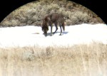
I really don’t know many people up in the Crandall area yet, nor do I know too many of the hikes.  I hiked with the wolf study gals last fall there a lot, but mostly that was through brush directly to GPS sites where their collared wolf had lingered for more than an hour.

So I stopped and introduced myself at the Hunter Peak Ranch.  Its an old dude ranch that now mostly houses guests and horsebackriding.  The owner, Shelley Cary, was very gracious and I talked for a while with her and her family.  They serve dinner to guests and outsiders with advance notice.  Something good to know for any guests I have.  They also had some great ancient photos on the walls of homesteaders from the Crandall area.  Several names I’d heard of.  One of them, Norman  and Mrs. Dodd, homesteaded in my area.  Apparently people always had to refer to Norman’s wife as Mrs. Dodd.  They lived ten hard miles from the meeting house, which was a one room schoolhouse, and came by a team of mules pulling a buckboard.  Another photo was of the old post office, a long wooden building in disrepair.

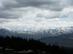
I took a short 5 mile hike along the Clark’s Fork trailhead. The Clark’s Fork trail is well marked and well used by horses.  Its in open sagebrush, so if a hiker does encounter a bear, there’d be plenty of room to move.

Geum triflorum.  Prairie Smoke

Geum triflorum. Prairie Smoke

Claytonia lanceolata.  Spring beauties.  Edibles.  Purslane family

Claytonia lanceolata. Spring beauties. Edibles. Purslane family

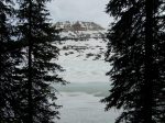
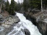
I’ve been on this trail before and knew of a wonderful secret spot where the river drops into a gorge.

Lunch spot

Lunch spot

I wandered off-trail to the waterfall.

Allium.  Wild onion. Spicy addition to lunch.

Allium. Wild onion. Spicy addition to lunch.

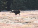
There was plenty of moose sign in the willows around the river, as well as a pair of nesting ospreysKoda and I sat and hung with the fish hawks for a while.  The female was sitting on her nest, although she took some time out to try and scare me off.  The male sat nearby with a piece of fish in his talons.

Female sitting on her nest

Female sitting on her nest

Male osprey nearby nest, with fish in talons

Male osprey nearby nest, with fish in talons

There’s always a plethora of anti-wolf talk in our area.  Besides aggrieved hunters and ranchers, I once talked with a woman whose parents ran an outfitting company.  She was only 16 and hated wolves.  She told me a story about how they had taken their supplies in the fall up to a campsite in anticipation of bringing some hunters up there the next day.  They’d left three dogs with the supplies, alone, overnight, way up near the Yellowstone border.  This was something they were used to doing, for years.  But this year was different.  When they returned the following day, one of their dogs had been killed by wolves.

After lunch, on the way back to the trail, I ran into a fellow resting his horse.  I introduced myself and found out he was a local.

“Find any horns?” he asked.

Horns refers to antlers.  People around here spend lots of time looking for antler sheds in the spring.  They can be worth big money.

“Nope, wasn’t looking for any.” I replied.  “But I did find a pair of nesting ospreys and moose sign.”

“I saw four wolves up on table mountain.  They’ll eat your dog, you know.  Just like that.”

“Yep, that’s why I keep him on that electronic collar.  We have an agreement he and I.  I protect him from wolves and he watches for bears.”

“Those frickin’ wolves, they’ve ruined everything.  There used to be so many bull elk here.  I wish they’d never put them here.”

“I like them.”

“They’re everywhere.  They ran after an elk right through the trailer park the other day.”

I didn’t think he heard me so I said it again.  “I like them here.”

“There’s no more moose anymore.  They’re history.  They’ve frickin’ ruined it all.  Things used to be good.”

“I seem to be seeing a lot of moose this year.  Maybe their numbers are coming back.”

“Oh, where you live maybe, but not here.  Wolves have ruined it all.  Last year we found three bull elk kills up Crandall creek.  They just hone in and kill them.  There’s no more left around here.”

I didn’t bother to tell him that I knew the elk study coordinator had hiked up there this winter and taken samples of the bull kills he’d seen.  He said their marrow was like jelly, an indicator of poor health.  I mentioned all the grizzlies in the area.

“Oh, those grizzlies don’t do much.  Its those damn wolves.”

That’s a typical conversation I’ve had many times.  There is a lot of animosity and anger about the wolf introduction.  These are people who live on the land and know the land, at least in a certain way.  They know where the wolves are denning even though the Game & Fish keep it secret.  They see grizzlies when they’re out. They feel comfortable in the outdoors, but they have been used to not having wolves around for a very long time.  And they resent having to take them into account now.

Its a most controversial matter, wolves.  I tend to be on the side of the wolves, but I also am sympathetic towards the ranchers.  I feel that its’ important to work with ranchers and begin to develop practices that protect their livelihood.   I also know that these large ranches are one of the last ways we can protect the land here.  If the ranches and ranchers are not taken into account, if they loose their land, then those large tracts will be sold and chopped up for development.  That in itself is even more of a death blow to wildlife, especially grizzlies and wolves.  New ranching management practices are critical for wildlife protection as well.  As one of the wolf researchers said to me last year “Something’s got to change. There’s just too much killing going on” in reference to all the wolves killed by Wildlife Services in retaliation for calf predation. (For a video of wolves in my valley, click here)
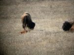
Wolf on carcass

Wolves on carcass

In contrast, I was reading in the Wind River Reservation Wolf Management Plan about how some of the elders of the tribe view wolves.  There is controversy on the reservation as well, the report says, because many Native Americans have livestock.  But there is magic, wisdom, and most importantly, respect, communicated in their ancient views.   Here is an excerpt from that report.

Traditional views recognize wolves as kin, as strong, as deserving of respect and placed here by the Creator for a purpose. The Shoshone word for wolf means “big coyote.” Wolves lived a long time, were very smart and observant, and listened well. When wolves appeared in a vision, one was to follow what the wolf showed you. The wolf was secretive and special and used to talk with people through telepathy. Wolves were helpers. Wolves were sacred and to be left alone, however sometimes people had to kill them. People were to be careful around them. Wolves could teach virtuous things to people. They were an example of how to care for family members because they took good care of the young as well as the old. The packing behavior of wolves showed people that they should not go out hunting alone. Wolves also showed people to use the entire game animal (the meat, bones, hooves, marrow, skin, etc.) – not to waste any of it. Wolves wandered to wherever the food was, like earlier people did. They did not know boundaries. Now wolves are being confined to certain areas like Native Americans have been confined to Reservations.Gray wolf

More Grizzly news around town

The Wyoming Game and Fish is finally starting their bear trapping and collaring in my valley.  They were supposed to start weeks ago, but the weather was too incremental, with several wet snowstorms, making it impossible to get far enough in to place the traps.  I know this only because one of the students who worked on the elk project this winter was supposed to help with the trapping.  Instead, because the work was delayed, he’s already off to Canada to work with bears there.

Our main dirt road travels directly west, ending about 7 miles from the Yellowstone boundary.  But those seven miles are straight up, through the shale and scree of the Absaroka Mountains.  If you can make it over the pass, you’ll end up in the Hoodoos, one of the most remote areas of Yellowstone.

Past the bear gate, the Absarokas are the eastern border of Yellowstone's wilds

Past the bear gate, the Absarokas are the eastern border of Yellowstone's wilds

The dirt road is maintained for about 25 miles from the Chief Joseph Highway.  After that its strictly four-wheel condition, and mostly only ATV’s can cross some of the creeks at the upper ends.

Past the bear gate its rugged and wild country.

Past the bear gate its rugged and wild country.

About 20 miles from the main highway, the road is closed till July 15.  That’s the ‘Bear Gate’.  People ask “Is that so the bears don’t get into the populated part of the valley?”  But the gate is so cars don’t go up there and disturb the bears.  The idea is that the Grizzlies can have their own space, undisturbed by cars, atv’s, people, when they emerge from their dens.  Its a great idea, but of course the grizzlies do what they want and roam free, which means they are up the valley this direction if they please.  But it does help to discourage weekenders and reduce human-bear conflicts.

Where do they go after July 15th?

Just 10 or 15 years ago, no one knew where Grizzlies went when they suddenly disappeared from the Park in early July.  One day a private plane was flying over the Absarokas and saw bears, lots of them, congregating on slopes of scree above timberline.  They were turning over rocks and boulders.  Usually solitary, this was a strange site to see groups of bears together.  It turned out they were looking for cut-worm moths and eating them at the rate of up to 40,000 a day.  I once saw these moths in the Wind River Mountains.  Thousands of them hanging under a rock crevice.  It was a sight I won’t forget.

The moths provide the bears with much needed fat for the winter.  At the end of my valley there is a glacier.  Its not uncommon to find the bears in the talus slopes in August.

Moths at high altitudes attract bears in my valley in late summer

Moths at high altitudes attract bears in my valley in late summer

Today I drove up the valley for a short hike across the river to a Sulphur Lakebed.

Sulphur deposits around the lake.  Lots of grizzly sign here

Sulphur deposits around the lake. Lots of grizzly sign here

On the way, I stopped and chatted with some new young forest rangers.  I asked about the collaring and if it had begun.

“They’re trapping at the bear gate.  Just a bit beyond it.” They informed me.

I said I wished they’d let us residents know so we don’t hike there.  They put carcasses out as bait and I don’t want to be nearby. “I wish they’d tell us”, the young rangers replied.

I suppose its good science to have them counted and collared.  But I can’t help but feel “let the bears be bears.”

My hike today on the south side of the creek, quite a ways down from the bear gate, was full of fresh bear tracks and scat.

Front and back grizzly tracks.

Front and back grizzly tracks. Notice the penny for size. See the straight line of the grass under the toes

On the way back home, I met a neighbor who told me there were fresh tracks behind his ranch and he’d led the G&F fellows up to where they could place their traps.  There was a huge pile of scat on the road as well. Last week I ran into fresh tracks in two drainages on the north side of the road.

Bear scat with trash collected on my hike today.

Bear scat with trash collected on my hike today.

My valley is where ‘problem bears’ are dropped off.  They take them to the bear gate, or beyond, and let them go, with the hopes they’ll go into Yellowstone.  A problem bear was dropped off just last week.  I think we average about 4 or 5 problem bears a summer.

Several years ago, I had the privilege of riding around with Mark Bruscino for an afternoon of bear education up the North Fork.  We didn’t see any bears, but I learned a lot talking with Mark.  Mark is the bear specialist for Wyoming Game and Fish.  He’s been working to restore the Grizzly population for over fifteen years.  I asked about the problem bears.

“Tell people that the bears they really don’t have to worry about are the problem ones we drop off.  Within days they ‘home’ back to where they came from.”

I think the relocation is an exercise in public relations, with a hope and a prayer that the bear learns something once he gets ‘home’.

The cool thing about hiking in grizzly country is the need to stay alert and aware.  In California, I could hike, think, talk, and space out all at the same time.  But hiking here, in the Greater Yellowstone area, I have to stay aware of my environment all the time.  I listen, I slow down, I look around; and so I notice so much more.  That doesn’t mean being tense. It means being conscious.  I think that’s how we’re all meant to be living all the time.  Taking the predators away, well, we’ve just forgotten.

Grizzly photo taken in Lamar Valley last sunday, mother's day

Grizzly photo taken in Lamar Valley last sunday, mother's day

An Advertisement for Yellowstone!

Happy Mother’s day.

Since my son is in New York, I gave myself a present.  The last few days have been either too busy or too cold to go into the Park.  I heard the road opened earlier than the scheduled date, Friday, the 8th.   So on Thursday I headed up towards Cooke City.  I never made it because of a snow storm.  Not that the snow was so bad, but I figured the animals wouldn’t be out.

This morning I woke up early and was out the door by 7am.  I’m only 40 minutes from the Park’s entrance; an hour from the Yellowstone Institute in the Lamar Valley.  Because I had the dog, my plan was to visit for 1/2 day, and take a hike outside the Park the other half, with the dog.

In the span of those 3 hours in the Lamar (or on my way there), I saw: (disclaimer…sorry my photos up close are not great.  I just have a small digital camera that I use because its lightweight for hiking.  Maybe I need to get a better one as well.)

Elk in my Valley.  I thought elk on left looked quite pregnant.

Elk in my Valley. I thought elk on left looked quite pregnant.

First thing on the way to Chief Joseph were some early morning grazing elk.  They are getting ready to calf soon.  My neighbor, on whose pasture these elk are grazing, called me yesterday to tell me to watch my dog as a wolf walked past her daughter yesterday.

Moose on Chief Joseph Highway

Moose on Chief Joseph Highway

These two moose were up past the 212 turnoff to the Park, right alongside the road.  I didn’t see any moose in the Park, although usually some hang out in the river right past the NE entrance.

This one just sat and watched me.  She had frost on her fur.

This one just sat and watched me. She had frost on her fur.

Here’s the approach to the NE entrance.  There was no ranger at the gate today, so no entrance fees.  Happy Mother’s day.

Entrance to Park

Not too far into the Lamar Valley, I stopped by a crowd with scopes.  I watched 2 wolves for a long time, one a collared gray female and the other a black.  They seemed to be trying to figure out how to cross the creek and road to get back to their den on the other side.  There was a lot of howling and prowling.

This is through the scope.  He was way across the Lamar river.

This is through the scope. He was way across the Lamar river.

Pronghorn were all over the hillsides.  Bighorn sheep were grazing high up.  I continued down the road a bit, still wanting to see some Bison babies, when I was distracted by another black wolf of the Druid pack, very close to the road.  I stopped and watched with my naked eye.  He was walking back and forth along the stream bed.  He was so close to the road that I thought he wanted to go to the other side as well.   Suddenly, he had something in his mouth.  It was a fish!  He brought the fish over to a nearby snowbank (all this within 200 feet or so of the road), played with it,  rolled on top of it, then devoured it as a magpie watched.

Wolf eating a fish he just caught

Wolf eating a fish he just caught

Wolf eating a fish

Wolf eating a fish

Finally I moved on to see the Bison calves.  The one animal we don’t have in our valley next to Yellowstone is Bison.  They wouldn’t be allowed to migrate out of the park.  Granted, they do shoot a lot of wolves outside the park, but they return and soon reform local packs.  In addition, each state is required to have a certain amount of wolves in their delisting program.  But Bison no state will tolerate because of the perceived threat of brucellosis to cattle.

Here are the baby pictures:

Bison calf

Bison calf

Mom with two calves in the grass nearby

Mom with two calves in the grass nearby

If all this wasn’t enough (I’d barely driven a mile within the Lamar), I went a short distance down the road to view the Grizzly hanging out within 100 feet of the highway.  He’d been there all morning.  On my way, another black wolf walked through a herd of grizzlies.  He was joined by a grey and they both began howling.  They were answered by a wolf on the other side of the road, not visible to me, near their den site.  A coyote began yipping in tune to the wolves, and then he sauntered across the road.  Several Red Tail hawks circled overhead, while Sandhill Cranes walked along the water’s edge.

Here is the bear:

This grizzly spent hours upturning Bison paddies for insects underneath

This grizzly spent hours upturning Bison paddies for insects underneath

Grizzly rooting around

Grizzly rooting around

I’ve oftened pondered what makes for that special nurturing quality of Yellowstone.  I left the valley and could feel its warm embrace.  There is so much life there.  The animals seem at peace, not threatened.   They are simply doing what they do, going about their business.  There is always a palpable feeling in the air there, like a slice of heaven.  Is it the volcano living underneath?  All the hot springs?  I think its where the natural order of things are in place.  In Yellowstone, man is not the top predator.  This has been so for generations upon generations of wildlife and they ‘know’ it.

It is time to acknowledge Yellowstone for what it truly is–the serengeti of North America–and treat its surrounding environs as such.  Outside of the Park, they are supposedly ‘protected’, but special interests always come first.  Buffalo cannot migrate to lower ground in the winter or they are killed; wolves even when they weren’t delisted were killed regularly (they know what the sound of a helicopter means outside of the Park); right now is bear hunting season in my valley.

The income from open grazing or from hunting tags pales in comparison to tourists coming to see our ‘Serengeti of wildlife’.  Having the Cattle or Sheep lobbyists win every legislative battle is old school.  It is time we see what we have here that is truly of value, and so unique.  It is time to preserve this land of the Greater Yellowstone Ecosystem, not just Yellowstone Park, and manage it with wildlife as the number one priority.

There couldn’t have been a better advertisement for Yellowstone as this mornings two hours in the Lamar Valley.

Some Scat

I thought I’d post a scat entry with photos.  Some I’m sure of, many I’m not.  Not all have size references.  Sorry about that.  I’m now starting to carry around a penny which I’ll put with future photos.  A penny is exactly 3/4″ in diameter.

Breaking up scat helps in identification and is a window into what the animal was eating.  Smelling scat (do not smell raccoon scat as they can carry a parasite that is fatal to humans) also holds clues.

Animals communicate vast amounts of information through markings and scat.  Many times I’ve watched Koda intently smell an area, then urinate on it.

Koda with his nose in a squirrel hole

Koda with his nose in a squirrel hole

One time he was smelling a log that had no obvious scat on it.  Because he is still a pup, he started licking the log to ‘uptake’ the smell better.  I got down and smelled the log and was overpowered by a extremely pungent smell.  Other times he spends a lot of time smelling an area and when I put my nose to the ground, I can’t discern anything.

One time in California I was at the tracking club meeting.  We were circling a large field and found mountain lion scat.  The group leader advised everyone to get down and sniff it.  One whiff of that scat and you’ll never forget it.  It made the hairs inside my nose stand on end for a long time.  Imagine your kitty litter box, then multiply that smell 10-fold.

Last year in the spring I had both my dogs with me in Wyoming.  My old dog started making a beeline for the woods.  I followed her to a fairly fresh turkey kill, probably from a coyote.  The kill was in the nearby vicinity of the cabin and the magpies were already on it.  The 2 dogs spent lots of time chewing and further demolishing it. Early the next morning, on the walkway in front of my house, a coyote left his fresh scat.  My old dog smelled it, but before I could hardly look at it, the 6 month old dog gobbled it up.  Koda was still learning about smells and scats, and eating it is another way to really remember it.  (I, personally, will not go that far!)  I had the distinct impression this particular scat was left for my dogs as a calling card, as if to say, ‘this is my territory and that was my turkey you fooled with.’

I’m a crazy beginner at this.  I find it’s a fun way to explore what’s happening around me. Learning scat takes practice and lots of direct experience.  I take photos, then go home and look at Mammal Tracks & Signs by Mark Elbroch.  Elbroch’s book contains tons of color photos throughout.  He includes photos of tracks, scat, as well as sign.  The book is thick at over 750 pages. Too bad he doesn’t include ‘scratch and sniff’.

Unknown scat

This one's unknown, found in the woods nearby

Marmot in hole with scat above

See Marmot scat at top of photo. Marmot's in his hole.

pack rat scat

Years of pack rat scat.

Canid scat

Could be coyote or wolf. 25% of wolf scat is coyote size.

Bobcat I think.  Smells like it.

Smelled like a cat. Bobcat I think. Cat's digest 90% of the bones.

Owl droppings

Owl on tree. Notice the white droppings.

Bear sweet smelling scat in the spring

Big pile of bear scat. All forbs/grasses. They clean themselves in the spring with grass.

Mustelid I think.  Smelly and strong.

Some kind of mustelid I think. It was skunky smelling.

Another mustelid, I think.  On the same trail as the other scat.

Another mustelid, I think. On the same trail as the other scat.

Grizzlies and the Edge of Eden

The last two days I hiked into several drainages where the hottest spots of the Yellowstone 1988 fires burned.  After 20 years those soils are still so sterile that no new trees are growing.  Hottest area of the '88 fires.  Sterile ground, good forage
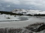
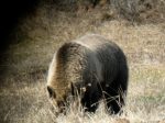
This is an area of excellent forage though, with young sweet grass and sagebrush.   Pulsatilla flowers just emerging nowThe snows are just beginning to melt and seasonal streams are running.  With a forest of dead timber, standing and downed, the run off will be fast and furious.  But its early still and the streams are gentle.  A huge log jam up river, crazy every which way, testifies to last years’ fury.

In summer, without the advantage of shade,  this place is too hot to hike in.  In the fall, it is full of hunters hoping to kill bull elk migrating from the Park. There is a strangeness here, the dead trees stand as sentinels against the hoodoo-like rock carvings from ancient lava flows.Dead trees and lava hoo doos

This is grizzly country.  They inhabit these draws, drainages that rise abruptly into high meadows; forests thick with Lodgepoles and Limber  Pines.  Spring is the best season here.  The dead timber provides homes for insects that attract an abundance of birds.  A woodpecker fights a flicker for territory, running him around and up a dead tree.  Finally the flicker retreats.  I find it curious this jockeying for dominance in an area of abundant food.There is a strangeness here

We saw grizzly tracks both days.  On the second day we followed a grizzly trail, although we were backtracking him. Grizzly track 
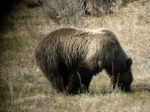
The trail, not on the map, was a highly used game trail that went up the wide mouth of the drainage. At times the downed trees were so thick the trail disappeared.  When the trail faded, we watched where the grizzly had chosen to go, figuring he’d have taken the path of least resistance.  It led up the creek bed, the stream disappearing and reappearing in odd places.   At one point, we crossed under a large downed tree trunk,.  The tracks passed directly underneath so we looked for fur stuck to the nubby remains of the branches.   There were a few hairs there.  Claw marks on trees noted where a grizzly stopped to mark his territory.  They were so high I couldn’t reach them.  That’s a big bear.Grizzly scratches on pine tree
Another tree with grizzly marks
A coyote,  running in our direction on the far side of the draw, suddenly smelled or heard us, and decided to turn back.   A bloody leg dangled from his mouth.  Koda noted the spot near the trail where the kill might be, but I called him back, fearing we’d find that grizzly there.  On the way back down, we walked over to the site Koda found.  A kill a few days old, the only remains was a small rib cage of a young elk or deer.

Its grizzly time right now.  They won’t be going high to find their moth sites until sometime in July.  Tonight  I watched a powerful video about  Charlie Russell called The Edge of Eden: Living with Grizzlies.   Charlie grew up in Canada  on an outfitter’s ranch.  He was a cattle rancher for years and had to deal with grizzlies.  He found that if he left out some winter kill cattle for the hungry grizzlies in the spring, they’d leave his cattle alone the rest of the year.  He wanted to understand grizzlies better and went to Kamchatka, Russia where the local zoos kill orphan cubs.  He began bringing these cubs back to the wilds, acting as their mother and protecting them for a year, sometimes two, then allowing them to roam free.  It’s a marvelous video  (that won several  film festivals) and story about a man trying to help restore respect for the grizzly as well as pioneer new strategies for those living in grizzly country.  To order the video, contact skyfilms@xplornet.com.

Badlands, Wild horses, and natural gas wells

Yesterday was the Greater Yellowstone Coalition (GYC) Cody Chapter annual spring hike.   This year they decided to go to McCullough Peaks, outside of Cody.  McCullough Peaks is badlands east of Cody.  It’s also a wild horse preserve and parts of it are Wilderness Study area.

McCullough Peaks, named after Pete McCollough who drove cattle to the southfork in 1879 for Judge Carter’s cattle company, is a stark and beautiful landscape.  The earth tones vary from reds to purples to shades of tan.  Numerous and dangerous sinkholes line the broken trails.  Its a land that one might look at and say “Nothin’s here”.  But I’ve hiked it twice now in the last three weeks and I beg to differ.Badlands, McCullough Peaks

My first hike several weeks ago the land was just beginning to green up.  Now’s the time the desert is fertile and blooming, lasting about a month.  You have to time your hike a few days after a snow or rain, otherwise the mud is a murky maze, hard to avoid.  One of the GYC members said this land is part of the Crocodilian age, rich in fossils from the Eocene, 38 to 58 million years ago when seas covered and then receded from the basin.

Hiking close to the herd, W__ and I kept our 50′ distance, but the wild horses decided to check us out more closely.  A mare and her foal came over, sniffed us, and decided we were fine to be on their land.  Its amazing these horses can even survive.  With rainfall only 5 to 8 inches a year, they seem to find food.  The BLM maintains some stock reservoirs that the horses use, as well as the open range cattle.Wild Horses

Wild Horse

The GYC hike was to Peak 6224.  Although it’s only about a mile distance, I found the trek difficult going up and down barren, steep, slippery soil.  From the summit of Peak 6224, you could see the entire basin–Carter Mountain, Heart Mountain, north to Beartooth Plateau and Powell, east to the Pryors and the Big Horns.  The greens of the new grass highlighted the hues of reds and purples, with the snowy peaks as a backdrop.  It was beautiful.  Purples of desert soil

Sinkhole, some are large enough for a man to fall through

View from the peak looking east

GYC chose this hike because on the other side of the road from the hike is where the proposed Natural Gas development is.   At the end of the hike we continued on the road over the hill to view the site.  One well has already been drilled and the toxic waste holding pond is full.  The 6 acre pad is built, but because of low gas prices right now, the well is waiting to be functional.

Open smelly pit with toxic hydrocarbon and chemical waste

This pit is supposed to be protected from birds as well as mammals

Gas pad still not reseeded and recontoured

6 acre pad should have been reseeded and recontoured

Hillary Eisen of the GYC staff explained that this is the first of many proposed wells in the area.  This well was an exploratory drill and they seem to have found enough gas to justify continuing.  She also explained that the 6 acre pad is allowed for the trucks to get in and create the well, but they’re supposed to have re-contoured and seeded the area by now, which they hadn’t.  Also she said that they don’t need to have an open pit for the toxic water waste; that it could just as easily be in a container.  The pit is supposed to be covered so birds can’t get in.  The pit had a real toxic smell.  In addition, there was garbage everywhere when we drove up.  They’re supposed to clean up the mess they leave.

This is the well, capped for now because prices are low.

This is the well, capped for now because prices are low.

This well is on state land.  Several of the others are on BLM land.  The state leases parcels of land with little environmental impact necessary.  They justify their leasing on the basis of the land paying for schools.  The BLM as a federal agency requires input from citizens and reviews.  But, Hillary explained, almost 100% of the time they approve development requests.

Once the wells are drilled and operating (when natural gas prices go back up), either pipelines need to be built or trucks will be going in and out to transport the gas.  Traffic will increase, more holding ponds with more toxic waste will be built, and a large generator for the pumping will be operating 24/7.  The noise from this generator will be constant and deafening.  McCullough Peaks will be a very different place, more on the order of a mini-Jonas field.  The solitude that makes parts of these lands eligible for a Wilderness area will be no longer.Beauty and solitude of McCullough Peaks Wilderness Study Area

Natural gas may be, as Hilliary explained, our transition fuel to greener technology.  It has a lower greenhouse gas impact than oil does.  But that doesn’t mean we can’t drill in more conscious ways.  This site, with the garbage strewn along the road and the plot, the negligence in restoring the area, the open unnecessary and smelly pits, as well as the types of generators that will be involved with the noise levels in the future–all that is done in the name of low costs.  I would call it pure neglect and unconsciousness.

“Don’t let people push you and say you have to provide energy for the nation.  It is not unreasonable to say there is a point at which we don’t want this to become an oil and gas Appalachia.”–Gov. Dave Freudenthal

The Orphan Road

I am just counting down the days until the Park opens. Its frustrating because we seem to be last on the list.  The Park newsletter says May 8, if conditions allow, Chief Joseph will open to the Northeast entrance.  Yet treacherous Sylvan Pass opens May 1 with no conditions attached.Pilot and Index Peaks from Chief Joseph Highway, May/June

There are only eleven miles of unplowed good highway between Chief Joseph/Beartooth highway and Cooke City.  I’ve asked my neighbors several times to explain the politics of plowing that road.  Its complex because it would seem to be the responsibility of Montana, as Wyoming plows their side.  But from what I understand, no one wants to claim it.  Its the ‘orphan road’.  The Park maintains the Beartooth (hwy 212) because that’s a federal highway.  But the Beartooth highway is not plowed in winter, for obvious reasons.  And they don’t want to plow the small stretch from the Wyoming border to Cooke City in the winter, which would leave Hwy. 296 (via 212) fully open to traffic from Cooke City to Cody in the winter.  Instead, a local in Crandall grooms that stretch for snowmobilers.

The odd thing is that once you’re in Cooke City, the North Road in Yellowstone is plowed so the kids can get to school and Cooke City isn’t landlocked.  So if, for instance, I drove to the end of Chief Joseph and parked at Pilot Creek, skied the 11 miles to Cooke City, then how do I get into the Park without a car?    It’s 11 miles of sheer frustration.  The town of Cooke City would like it plowed (at least that’s what some of the local businesses have suggested to me), but they must be too small for political clout with the feds.

The town of Cody on the other hand has lots of political clout it seems.  They’ve pushed the Park every year to keep Sylvan Pass open as a groomed road for snowmobilers.  They seem to be under the illusion that keeping that entrance open attracts winter tourists and money for the town.  The figures for 2009 are in and only 97 snowmobilers went in through the East Entrance, at a cost of $325,000 to the Park.  That’s $3500 per snowmobile!  No snow coaches went through.

I’ve only been here 4 years, but here’s the logic the way I see it.  Sylvan pass is dangerous.  To keep the pass open and safe in the winter, the Park has to induce avalanches.  Its a treacherous road.  It’s beautiful but dangerous.  Chief Joseph highway via Dead Indian Pass, on the other hand, is plowed all winter.  It’s also incredibly beautiful and accessible via Cody and Codys’ airport.  The extra 11 miles of highway is a good road and not over a 8530′ pass.  My neighbor tells me they paved Chief Joseph always with the intention of it being the winter access into the Park.  So why doesn’t Cody push to open that in the winter?

It is because there is a false view that Cody is receiving winter business from their East gate.  Numbers say they aren’t.  But people could fly into Cody and drive into Mammoth or vice versa if those 11 miles were plowed.  I’m sure the costs wouldn’t be $325,000 to the Park.  Just the cost of paying the guy already plowing the North road a few extra bucks.

One group pushing to keep that part of the road closed is Cody Country Snowmobile Association. They argue that the area is world class snowmobiling, it attracts lots of people from out of state, and money is made for the state on the tickets for snowmobiles, as well as money spent in town by the tourists.

I’m no fan of snowmobiling.  They are too noisy for me.  I am a hiker and like to feel the quiet of the woods and see the animals.  But I’m sure if $325,000/year wasn’t spent on Sylvan Pass (the snowmobilers prefer the Beartooths anyways for its challenge and freedom), some of that money could be redirected (maybe in partnership with other state agencies that are likely to benefit) to create new access trails for snowmobiles, working out a plan that would please both the CCSA and people like me who want to gain access into the Park in the winter, as well as provide that extra revenue from tourists that Cody is looking for.

On the bright side, keeping that road unploughed, although we have lots of weekend car traffic from Cody to Pilot Creek with snowmobiles in tow, helps insure that my area of the valley is nice and quiet in the winter.   Maybe things are well enough left alone.  Regardless, I’m anxious for May 8 to take an afternoon drive into the Lamar and see the Bison babies.  Pronghorn in Lamar in spring--Northeast entrance

Spring storm brewing in Yellowstone, NE entrance

Lamar Valley, springtime

Chief Standing Bear and Grandpa

My neighbor JB was born in 1924 in my valley down by the Clark’s Fork.  His parents’ homestead is in a unique and beautiful hollow below the main road.  From this hidden depression, you can look out over the meadow where their horses graze and view Bald Ridge directly on.The flats above the gorge of the Clarks Fork

Bald Ridge

Yesterday it was snowing so I went to visit JB.  He told me this story:

My grandfather was born in Nebraska.  When he was just nine years old, he was playing and broke his leg.  His father was a hard man and beat him for that.  My grandpa swore to himself that when he got better he was going to run away and he did, at 10 years old.  He and a friend were catching rides on freighters going down river, going West.  They hitched a ride on a wagon that was attacked by Indians.  The Indians killed everyone in that wagon train, including his friend, but my grandpa hid in a flour drum.  The flour was in 55 gallon drums and he hid behind one.   The Indian Chief and his wife found the boy and the Chief’s wife took pity on him.  They took him back to the tribe and raised him with their own child, which I think was a girl.  That Chief was Standing Bear.  My Grandpa lived with them for 5 years. Chief Standing Bear--I think its this one.

The Indians liked to gamble and compete.  There was one boy the same age as my grandfather who didn’t get along with him at all.  When my grandpa was 15, this boy challenged my grandfather to a horse race.  Grandfather was an excellent horseman and he was winning.  The Indian boy was mad and pulled out a knife.  Grandpa knocked that boy down, off his horse, and I think he killed him.  Or hurt him badly.  No, I think he killed him, but it was kill or be killed.

The whole tribe had a meeting.  Since my grandfather was white, they banished him.  Chief Standing Bear and his wife took my grandpa in the middle of the night, on horseback, and told him he should leave and go far away; far enough away so no one in the tribe would come after him.  The chief told him that he would always love him and think of him as a son, strong, brave and worthy to become a chief, but that now he must go.

Photo of Chief and family from the Buffalo Bill Historical Center

Photo of Chief and family from the Buffalo Bill Historical Center

Grandpa came out to this country and spent time here with the Shoshone as well.  He was working at Pahaska Teepee taking people into the Park when Buffalo Bill came out here.

It is true he had a wooden leg.  He was logging and in an accident.  His leg broke, a clean break right here (points to below his knee).  He knew how to set bones and had set many breaks on other people. But they took him to a doctor who cut off his leg at the knee.  That shouldn’t have been.  He’d wear lots and lots of socks over that peg to cushion it against his knee.  But he could do anything he wanted with that leg.

He lived near the mouth of the Clarks Fork.  One time us kids were down there visiting.  My sister was taking a nap in the house and all of us other kids were down at the river swimming and fishing.  Grandpa was working in his shop nearby.  In those days there was lots of sheet lightening in this country.   My sister had just gotten up from her nap and was coming down to the river, when lightening struck the house.  You couldn’t do nothing.  In an instant, the entire house was in flames.  My grandpa thought my little sister was still in the house.  You should’ve seen him run with that peg leg!

I went to live with my grandpa when I was about 12.  I had a hard time finishing up those last two years of school between the 6th and 8th grades.  I did graduate though.  I only went till 8th grade.  Sometimes I was on the other side of the mountain going to school there.  They had a better teacher.  Sometimes I had to come back home and go to school here.  There were only 3 students here and all that teacher was interested in was the ranch hands. All that back and forth on foot and horseback over Dead Indian.  There wasn’t a real good road in those days, all dirt.  The old road went straight down the mountain.  From Cody it took four stout horses to pull an empty wagon up the hill most of the day. When you got to the top of Dead Indian, a man put a roughlock shoe on his hind wheels which kept them from turning.  Then he cut a tree, left all the branches on it, and chained it behind the load.  Then he headed straight down the hill, praying that his leaders would outrun his wheelers.Atop Dead Indian.  Strap a log behind the wagon to go downhill

Grandpa had really strong hands, all his life.  It was because he had spent so much time driving teams of horses.  You have to hold those reins between each finger and use your hands to hold back the horses.  He drove hay and other goods for a living.  I think he had done just about everything.  He was an excellent blacksmith and made all his tools.

It was a good story for a snowy day.  I thought about how I was just one hair’s breath away from Chief Standing Bear.  How less than a hundred years ago men knew how to do everything in order to survive–how to set a bone, fire and hammer out their tools, drive a team of horses.  I thought how our lives had become so quickly removed from those generations– so flaccid with the advent of electricity, large machinery, computers, phones–and wondered how much lore and skills have already been buried forever.

When I talk story with JB, I can feel him reaching back in his mind.  He has an impeccable memory for details. His stories contain names and dates.  He might have only an 8th grade education, but his powers of observation far surpass many I’ve met with college degrees.  I get him to tell me stories.  I write them down.  I listen.  They need to be re-told.

Getting to know my neighborhood at twilight

There’s a wonderful little forest next to my house.  Its where seven springs emerge out of the limestone that feed the cabins around here.  A trail leads through the woods to the meadows beyond.  Even though these woods are not large, and are surrounded by cabins, its a bustling place.My Little Woods

Deer, turkeys, coyotes, moose (on the lower end its marshy with willows), black bear and sometimes grizzlies, and plenty of small mammals frequent the area.  I’ve been trying to get to know my neighborhood, so I walk through the woods, exploring its smells and tracks, at least several times a week, mostly at dusk.

Last week I called a Great Horned Owl.  We had a nice conversation, back and forth.  He was roosting somewhere on the hillside, when a band of turkeys came noisily through the brush.  Maybe he didn’t like them scaring his potential dinner every which way, because he burst through the trees and flew down to the lower ends of the forest.  I did have to wonder if some of those turkeys’ young would be a nice meal for him this spring.

Several years ago, after the Point Reyes fires in California, the Park Service obtained money for Spotted Owl research.   I was lucky enough to help in the three year study.  My area was in a State Park with Redwoods and Douglas Fir, some of it old growth.  The first season was about locating the owls.  We learned to imitate their calls.  Owls, I found out, don’t care how exact your call is.  If I kind-of sounded like a spotted owl, they’d call back.

The next season we ‘moused’ the owls in order to find their nests and estimate the number of breeding pairs.  We brought lab mice into the field.  Since we already had an idea of the territory of the owls from the year before, we hiked to those areas, called in the owl, put the mouse on a stick and the male would take the mouse back to the female on the nest.  The third year we counted mature chicks.  The main predator of Spotted Owls is the Great Horned Owl–“The Lion of the Night”.

Helping with that study I learned a little about looking for owls.  The best way to find an owl is to spot their droppings around the base of a tree. Droppings at base of trees indicate owl roosts I’ve looked for this before in those little woods and easily found the roosts of Great Horned Owls and their pellets.  Pellets are not owl scat but the undigested parts of their food, regurgitated up in a large pellet.  If you open the pellet up, the evidence of their meal(s) is right there in the form of bones and hair.

Tonight though I was in for a surprise.  I was tooling around the woods at dusk like I do several times a week.  I decided to follow a deer run under some brush when I spotted some droppings at the base of a snag.   I bent down to get a closer look, and spooked a bird out from the top of the snag.  The bird flew to a nearby tree.  I felt there was something unusual about this bird so I told the dog lie down and I slowly crawled out from the low hanging branches and looked up.  It took me a few minutes for my eyes to adjust to the dim light and understand what I was seeing, as at first the bird seemed like a large robin.  It was a small owl, about 7 inches long, just as curious about me as I was about it. I adjusted my eyes I sat down on a log, watched and talked to the bird.  I found a pellet beside the log, about 1/2 the size of a Great Horned pellet.  After a long time, I crawled around and hung out with the bird from a closer and better angle. The owl wasn't afraid The owl wasn’t afraid at all.  In fact, he reminded me of Spotted Owls.  When we did our study, I was sworn to secrecy as to where the owls were located.  Spotted Owls are so tame that they can easily be approached and because they are endangered, we were especially careful.  This owl even started falling asleep while the dog and I sat there (Spotteds spend a lot of time sleeping too).

Hanging with that owl, I could see why there is a lore about them being ‘wise’.  Looking in his eyes, so close, he had an intensely calming effect on me.  Koda and I bade our goodbyes for the night and I went home to look up his name.  The Northern Saw-Whet Owl. I know Screech Owls also live in those woods because I hear them frequently.  But so does the ‘Lion of the Night’.  Stay safe little owl.Northern Saw-Whet Owl